Ice cores from East Antarctica could be used to improve water security decisions and drought planning and management, for agriculture and other sectors in eastern Australia, according to research involving Australian Antarctic Program scientists.
The research focused on water catchments in south-east Queensland (SEQ), and found that modelling based on instrumental rainfall records (rain gauges), spanning the past 60-120 years, may underestimate the probability of drought.
However, Antarctic climate scientist Dr Tessa Vance, from the Institute for Marine and Antarctic Studies, said palaeoclimate data in ice cores could provide a better understanding of drought frequency and duration extending back centuries or millennia.
“The short-term instrumental rainfall records in Australia do not encompass enough climate variability to get a reliable understanding of the risks of multi-year droughts or major flood events,” Dr Vance said.
“However palaeoclimate data, such as that found in ice cores, tree rings, or corals, can extend hydroclimatic records by thousands of years, providing greater insight into what is possible in terms of drought frequency and duration.
“This will improve estimates of current and future water supply, and enable Australian water supply agencies to better plan for rare but high impact droughts.”
The research team, led by Dr Anthony Kiem from the Centre for Water, Climate and Land at the University of Newcastle, analysed climate signals in ice cores from Law Dome dating back to the year 1000.
Dr Vance has previously shown a relationship between yearly summer sea salt concentrations in the ice cores and rainfall variability in SEQ, making them a useful proxy for broader hydroclimate studies in eastern Australia.
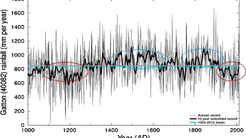
The team used the ice core records to reconstruct pre-instrumental rainfall in the study location, between 1000 and 2012, and compared this to drought statistics calculated using instrumental records from 1900 to 2012.
“The results suggest that the instrumental record underestimates or at least misrepresents the full range of rainfall variability that has occurred and is possible in SEQ,” Dr Kiem said.
The instrumental record contains three major droughts – the Federation (~1895-1902), World War II (~1937-1945), and the Millennium drought (~1997-2010).
The ice core records show that the lengths of these three major droughts were matched or exceeded several times prior to 1900, including from 1100 to 1250. Some centuries were drier than others, but there were also long wet periods, from 1400–1650 and 1750–1900.
“Our results indicate that current drought risk estimates based on the instrumental record are misleading and probably convey a false sense of security that is not justified given the insights from palaeoclimate data,” Dr Kiem said.
“Further research is needed to collect, develop and compare different palaeoclimate records, and to refine the accuracy of these records, to maximise their usefulness for drought planning, agriculture, water management and water security decision making.”
The research was funded by the Queensland Department of Environment and Science, Seqwater, and the Australian Research Council. It was published in the Journal of Hydrology – Regional Studies in April 2020.


