The Tasman International Geospace Environment Radar (TIGER) is an Australian initiative to study the Earth’s geospace environment in order to extend our scientific knowledge and improve space weather predictions. TIGER will consist of two High Frequency radars, one in Tasmania and one in New Zealand, with intersecting beams looking toward Antarctica. The radars will survey the ionosphere, providing measurements on the behaviour and characteristics of aurora and other phenomena. TIGER will operate as a stand-alone radar but will also be part of SuperDARN (Super Dual Auroral Radar Network), an expanding international network of radars being established to provide coverage of northern and southern hemisphere high-latitudes. TIGER’s specific location at a lower latitude than other radars in the network, will enable it to make unique contributions to the international program.
Geospace and space weather
The solar wind consists of ionised particles, streaming outwards from the sun at ~300–800km/s and carries with it the Interplanetary Magnetic Field (IMF). Earth’s magnetic field acts as a barrier to the IMF and solar wind particles. As the solar wind streams past Earth, the terrestrial magnetic field is compressed on the dayside and extended on the nightside, giving the magnetosphere (the region of influence of Earth’s magnetic field) a comet-like shape. Geospace is the near-Earth space environment consisting of the ionosphere, magnetosphere, and nearby solar wind. It is a vast region extending from about 50km altitude to geocentric distances in excess of a million km. Like weather on Earth, that in the ionosphere — the region between 100 and 800km above Earth’s surface where satellites operate — is changeable. There can be winds up to 1km/s, variations in temperature of more than 100ºC and changes in atmospheric composition. Most extreme ionospheric events are caused by the sun ejecting large amounts of matter in Coronal Mass Ejections (CMEs) and solar flares.
When CMEs are directed towards the Earth, they cause large magnetic storms that greatly affect the magnetosphere, ionosphere and thermosphere, producing spectacular auroral displays at locations where the aurora is rarely seen. The varying conditions of geospace, including these dramatic storm effects, are referred to as space weather.
Accurate space weather predictions are of increasing economic importance because of the deleterious effects caused by magnetic storms on such devices as communication and Earth resource satellites, and electric power grids. Forecasting such storms, or ‘nowcasting’ — informing appropriate authorities that a space storm has started — may enable them to switch off or change to backup systems. Also, high space winds increase drag on satellites in space, causing them to slow and change orbit. Unless low-altitude Earth-orbit satellites are routinely boosted in height they fall slowly and eventually burn up in the Earth’s atmosphere.
Auroras are the only sign of space weather visible to the naked eye from Earth. They are geomagnetic storms in which electrons and ions enter Earth’s atmosphere near the poles striking molecules and atoms in the high atmosphere, causing them to glow in different colours. Some aspects of space weather, including magnetic storms, affect much of modern technology. Magnetic storms can disrupt many communications systems which use the ionosphere to reflect radio signals. The same applies to sea and air navigation systems.
Geologists searching for oil, gas or mineral deposits use the Earth’s magnetic field to find subterranean rock structures — but can only do so when the Earth’s field is quiet. Knowledge of when storms abate, or are about to start, therefore has commercial implications.
Another relevant area of commercial importance is electricity transmission. During geomagnetic storms, magnetic fields interact with such conductors as wire, and induce an almost direct electric current. Thus they interfere with alternating current in power transmission lines and cause harm to equipment. A warning of the approach of a geomagnetic storm, or even drawing attention to its presence, enables power companies to switch off or transfer power.
Other potential uses include medicine, as there is accumulating evidence that changes in the geomagnetic field affect biological systems. High-energy charged particles emitted during major bursts of solar activity are potentially lethal to space travellers, either in Earth orbit or on future interplanetary missions, and can also expose passengers on commercial jets at high latitudes to increased radiation levels. The list of beneficial consequences of knowledge about space weather grows in proportion to humanity’s dependence on technology, making the work of TIGER more important with time.
How does TIGER work?
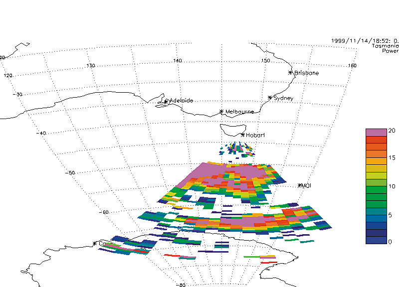
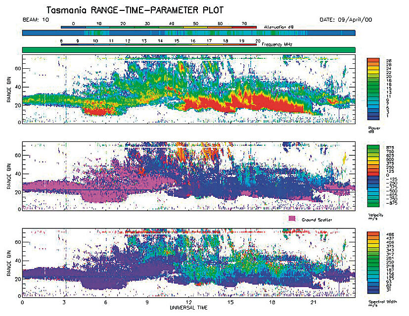
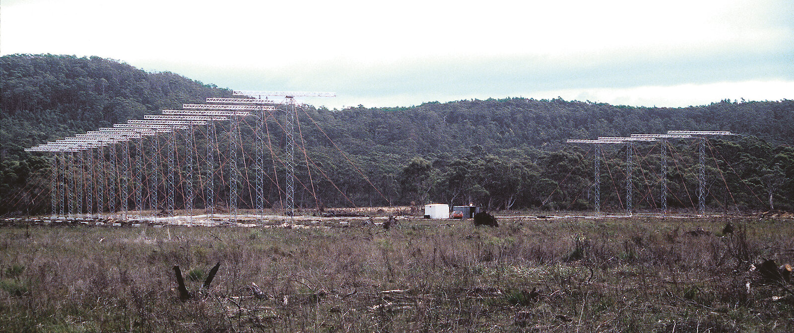
TIGER is an over-the-horizon radar, which transmits radio waves that are refracted by the ionosphere. A small amount of the radiated energy is backscattered by irregularities in the ionospheric plasma and is received back on the ground by the radar. The transmitting antenna consists of an array of 16 log-periodic antennas that form a narrow beam that is swept across the radar footprint in 16 steps. An additional four antennas placed behind the transmitting array are used to form an interferometer receiving array that measures the elevation angle of echoes. Subsequent processing and analysis gives us information on the velocity of the ionospheric plasma. Convection flows over a large region can be measured every 90 seconds. Velocity maps determined from TIGER provide an ‘instantaneous’ or ‘real-time’ picture of the convection of the plasma in the ionosphere and magnetosphere. Convection is the primary response of the magnetosphere to variations in parameters of the interplanetary medium, and to the coupling processes at the interface between the magnetosphere and the solar wind.
TIGER science program
The first of the TIGER radars is located on South Bruny Island and probes the ionosphere over an area approximately the size of Australia between Hobart and Antarctica. In the simplest terms, the radar determines the location of aurora and other phenomena in the high-latitude ionosphere, and measures the associated flow patterns. Hence it enables the driving forces, which include both magnetospheric and ionospheric processes, to be studied. The wide coverage of the radar also enables the propagation of effects to lower latitudes to be studied and this is particularly important for practical applications relevant to Australia. Basic research programs will be carried out to understand the fundamental processes involved, and applied research will be conducted to develop methods of predicting the impact of the various phenomena on the performance of over-the-horizon radar, communication circuits, and satellite operation.
TIGER is in an ideal location to study the expansion of the auroral phenomenon to lower latitudes that takes place during large magnetic storms. Sunspot activity is expected to peak during 2000–01 and large magnetic storms can be expected during the next two years.
The SuperDARN radar array will provide an ideal diagnostic for other experiments located at the Australian Antarctic stations, Macquarie Island and within Australia. Overall the TIGER radar will be a facility of international standing in the study of Geospace and it will ensure that Australia continues to play a leading role in this area of international basic and applied science well into the twenty-first century. TIGER will be linked to Hobart’s Antarctic Adventure to provide ‘real-time’ radar pictures of the Aurora Australis as part of an exhibit to inform the public on the majestic lights that appear south of and at times above Hobart.
Anthony Breed and Ray Morris
Atmospheric and Space Physics Program,
Australian Antarctic Division
Peter Dyson and John Devlin
La Trobe University