The Southern Ocean is renowned for being a highly productive region: the vast stocks of krill, the populations of whales that once fed off them and the emblematic hordes of seals and penguins all make their living from the waters that surround the Antarctic continent.
Intensive studies over the last thirty years, however, have shown that these waters are only productive in restricted areas and during a relatively short season. Furthermore, there can be great differences between years in the ability of the ocean to support the plethora of life that depends on it. Recently, a number of theories have been put forward to explain the temporal and spatial variation in the productivity of the Southern Ocean. These theories have viewed the physical factors such as sea ice and the major ocean boundaries as being the fundamental determinant of where and when productivity occurs. Winter sea ice is seen as a nursery area for krill which are nurtured by the algae growing on the underside. The more sea ice, the more sea ice algae and therefore the better the krill population survives and this success is propagated up the food chain. The boundaries between currents are seen to be areas where nutrient-rich cold, deep waters reach the surface, thus fuelling the production in spring. A combination of the temporal variation in the abundance of winter sea ice and the geographic location of the major fronts will determine which waters are more productive in a given year. Unfortunately, such large-scale phenomena are difficult to study and most of the information fuelling these theories has come from small-scale studies, mostly in the atypical Antarctic Peninsula region or from inferences from historical data. Until recently no survey had covered enough ocean in a single season to be able to examine some of these relationships in detail.
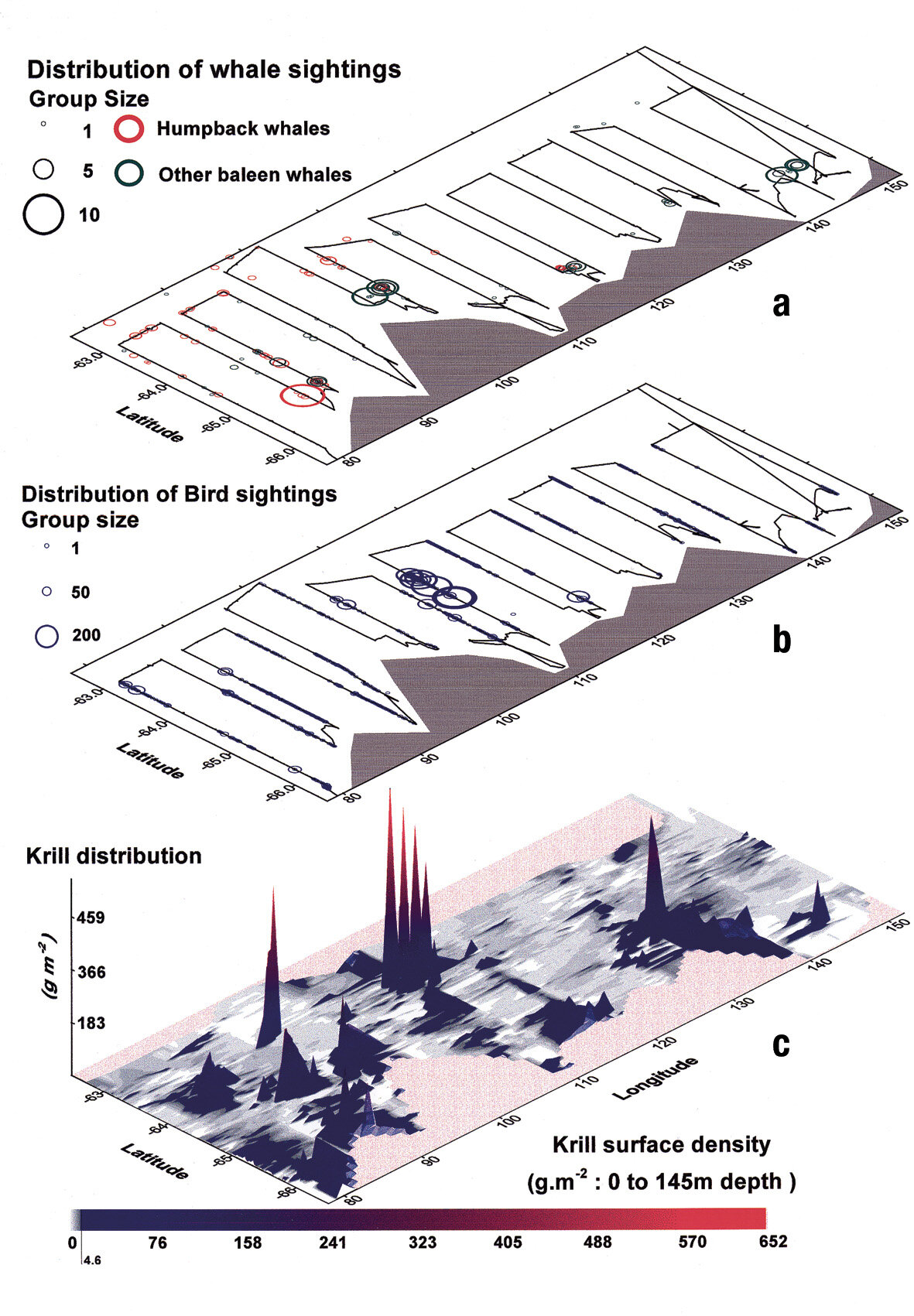
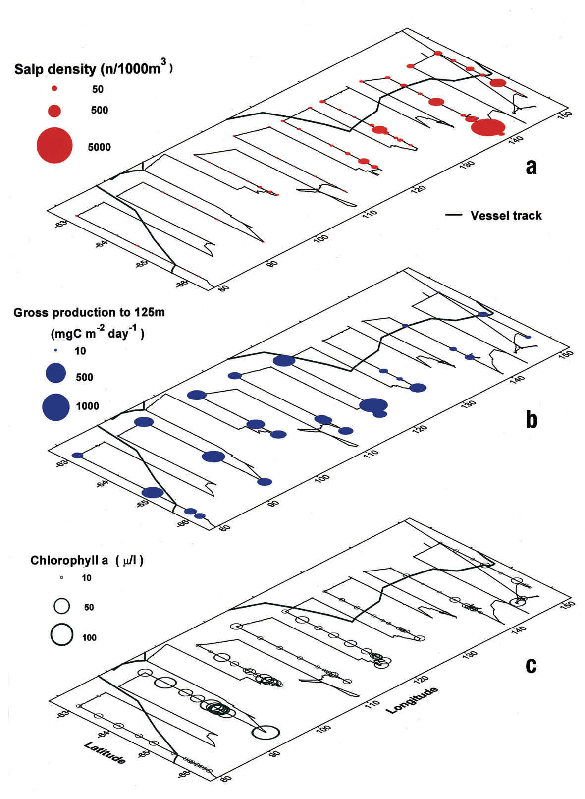
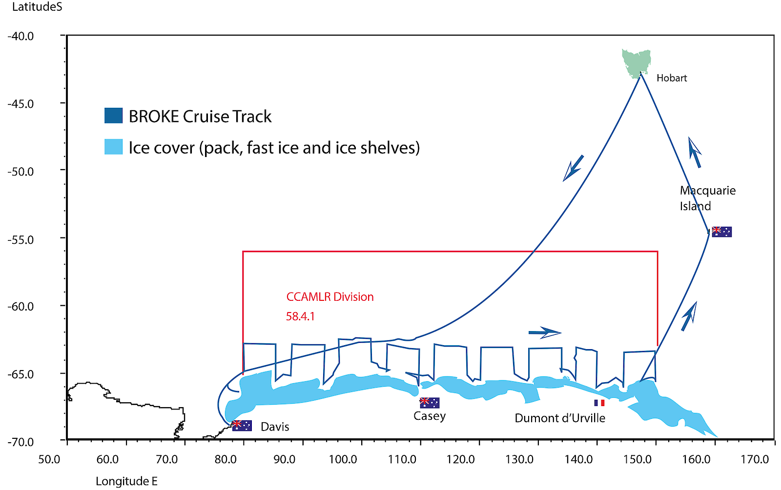
In 1996 the Australian Antarctic Program embarked on a major voyage which subsequently became known as BROKE (Baseline Research on Oceanography, Krill and the Environment). This voyage surveyed the biology and oceanography of 873,000km2 of the waters off East Antarctica. These waters had never been surveyed for krill before, so one of the aims of the survey was to estimate krill abundance to enable a catch limit to be set on the fishery. Similarly, there was little information on the oceanography of this region. A second aim of this voyage was to determine whether there were major sources of Antarctic bottom water along this coastline that might be important from the point of view of climate change. The voyage also studied a whole range of other biological and physical variables from ocean chemistry to the distribution of whales. This provided a unique data set which could be used to examine some of the ideas about the factors determining regional productivity.
Fortuitously, the area surveyed, between 80 and 150°E, is an area in which the winter sea ice extent varies by a factor of three from west to east. Thus the effect of the differences in sea ice extent between the west and the east on the distribution of biological production at all levels, could be investigated. In the west of the area (80–115°E) there was much greater biological activity; primary production was greater, and two-thirds of the krill biomass and nearly all the whales were located there. Production also stretched far north in a gyre which retained the cold water with which the productivity is associated. In the east, the warmer water of the Antarctic circumpolar current veered southward and the cold productive water was confined to a narrow coastal band. Consequently all forms of life in the 115–150°E sector were more scarce than in the west. The patterns observed were distinct throughout the physical and biological data and pointed to the water circulation enhancing production in the western half of the region.
Putting all the data together, it became apparent that the factors that were controlling the distribution of the living organisms were also probably controlling the distribution of the physical variables too. So rather than the sea ice determining the level of biological production, it is the circulation that determines both the biological productivity and the location where the sea ice is most extensive — they co-vary rather than one causing the other. We have used this insight to suggest that what we see off East Antarctica may be a geographic reflection of what is seen in other regions of the Antarctic. In seasons when there is more sea ice, this may be because the circulation pattern has pushed the warmer water offshore and the colder, more productive water dominates the coastal areas. When there is less sea ice this is because the warmer, less productive water is closer to the continent and the animals associated with the krill-rich cold water are displaced.
This new concept of how the Antarctic marine ecosystem functions was published late in 2000 in a special volume of the journal Deep Sea Research containing thirteen papers on the results of the research from BROKE and simultaneously in a conceptual paper in the prestigious British weekly science journal Nature. Additionally, the results were used by CCAMLR at its 19th meeting to set two new precautionary catch limits on the krill fishery off East Antarctica — 277,000 tonnes west of 115°E and 163,000 tonnes east of 115°E in any fishing season. The scientific and management achievements of this voyage must make it one of the more successful activities undertaken by the Australian Antarctic Program.
Stephen Nicol
Antarctic Marine Living Resources Program Leader,
Australian Antarctic Division