
For this compilation reference has been largely made to Dr HR Mill’s The Siege of the South Pole. Several doubtful voyages during the early part of the nineteenth century have been omitted.
1775
James Cook circumnavigated the globe in high southern latitudes, discovering the subantarctic island of South Georgia. He was the first to cross the Antarctic Circle.
1819
William Smith, the master of a merchant vessel trading between Montevideo and Valparaiso, discovered the South Shetland Islands.
1819
Fabian Gottlieb von Bellingshausen, dispatched in command of an Expedition by the Emperor, Alexander I of Russia, with instructions to supplement the voyage of Captain Cook, circumnavigated the Antarctic continent in high southern latitudes. The first discovery of land south of the Antarctic Circle was made, namely, Peter I Island and Alexander I Land (also an island), in the American Quadrant of Antarctica.
1820
Nathaniel Palmer, master of an American sealing vessel, sighted new land to the south of the South Shetland Islands. It seems clear that he was the first to view what is now known as the Palmer Archipelago (1820–21).
1823
James Weddell, a British sealer, sailing southward of the Atlantic Ocean, reached 74° 15’ south latitude in the American Quadrant, establishing a ‘farthest south’ record.
1830
John Biscoe, a whaling master of the British firm of Enderby Brothers, sailed on a voyage circumnavigating the Antarctic Regions. Enderby Land was discovered south of the West Indian Ocean in the African Quadrant of Antarctica. This was apparently a part of the Antarctic continent. New land was also met with to the south of America and charted as Graham’s Land, Biscoe Island and Adelaide Island.
Kemp, a sailing master of Enderby Brothers, extended Biscoe’s discoveries shortly after by the report of land east of, and adjacent to, Enderby Land.
Neither of these discoveries has yet been proved, though Enderby Land (Biscoe) undoubtedly exists.
1839
John Balleny, another of Enderby’s whaling captains, discovered the Balleny Islands within the Antarctic Circle, in the Australian Quadrant of Antarctica, and gave a vague description of an appearance of land to the westward. This has been charted on maps, without adequate evidence, as Sabrina Land.
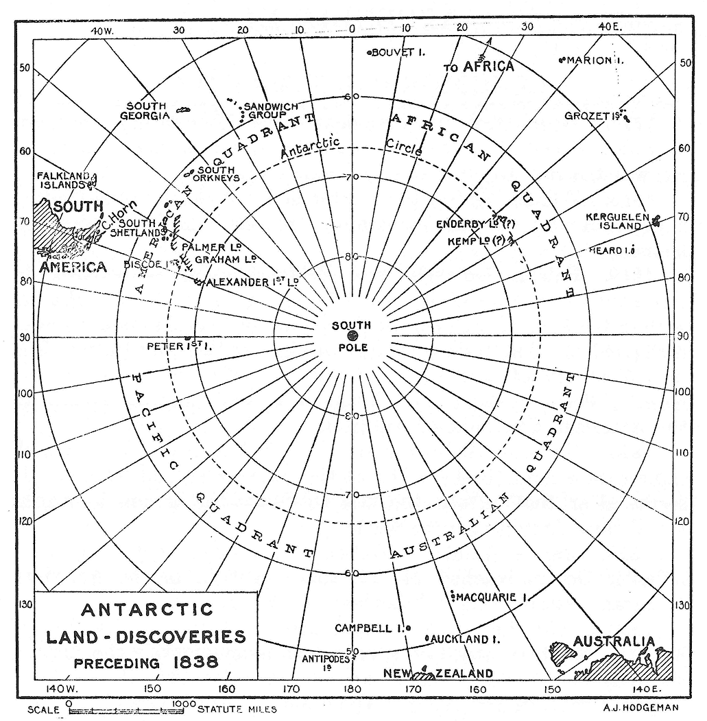
Antarctic land discoveries preceding 1838
Note: This and the two following maps of the series illustrate land discoveries only. In cases where the existence of land once reported has since been disproved no record at all is shown.
1837
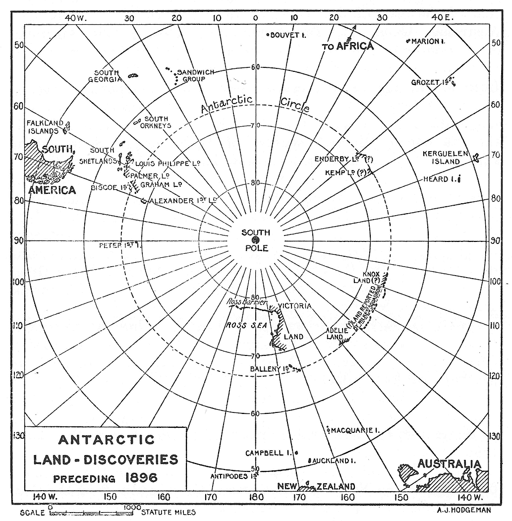
Jules Sebastian Cesar Dumont D’Urville, was dispatched by King Louis Philippe of France for the prosecution of scientific researches on a voyage round the World. His cruise in the Antarctic resulted in the charting of Joinville Island and Louis Philippe Land to the south of America (American Quadrant) and the discovery of a portion of the Antarctic continent, named Adélie Land, southward of Australia (Australian Quadrant).
1838
Charles Wilkes, United States Navy, in accordance with a bill passed by Congress, set out on an exploring expedition to circumnavigate the World. His programme included the investigation of the area of the Antarctic to the south of Australia — the Australian Quadrant. The squadron composing this American expedition first visited the Antarctic regions in the American Quadrant, and then proceeded eastward round to the Australian Quadrant from which, after a long cruise, they returned, reporting land at frequent intervals in the vicinity of the Antarctic Circle between longitudes 157° 46’ E and 106° 19’ E. He shares with D’Urville the full honour of the discovery of Adélie Land. Some of the supposed landfalls known to be non–existent.
1839
James Clark Ross proceeded south in charge of a scientific expedition fitted out by the Admiralty at the instance of the British Association for the Advancement of Science and approved of by the Royal Society. His aim was to circumnavigate the Antarctic regions and to investigate the Weddell Sea. The geographical results were fruitful; the Ross Sea, the Admiralty Range and the Great Ice Barrier were discovered and some eight hundred miles of Antarctic coastline were broadly delineated.
1844
TEL Moore was detailed by the Admiralty to supplement the magnetic work of Ross and to explore to the southward of Africa and of the Indian Ocean, but no additions were made to geographical knowledge.
1872
Eduard Dallmann, whilst engaged in whaling with a German steamer to the southward of America, added some details to the map of the Palmer Archipelago but did not go further south than 64° 45’ S latitude.
1874
The Challenger scientific expedition, under the command of George Strong Nares, in the course of their voyage from the Cape to Australia during the circumnavigation of the World penetrated within the Antarctic Circle in longitude 78° 22’ E.
1892
A fleet of four Scottish whalers cruised through the north western part of the Weddell Sea. Scientific observations were made by WS Bruce and others, but no geographical discoveries were recorded.
1892
CA Larsen, master of a Hamburg whaler, added important details to the geography of the American Quadrant of Antarctica on the western side of the Weddell Sea.
1894
Evensen, master of another Hamburg whaler, brought back further information of the American Quadrant on the Pacific Ocean side.
1895
HJ Bull organized a whaling venture and with Leonard Kristensen, master of the ship, revisited the Ross Sea area where a landing was made at Cape Adare (Australian Quadrant). This was the first occasion on which any human being had set foot on the Antarctic continent.
1897
Adrien de Gerlache sailed from Belgium on a scientific exploring expedition to the American Quadrant. Important additions were made to the map, but the ship became frozen into the pack ice and drifted about for a whole year south of the Antarctic Circle. The members of this expedition were the first to experience an Antarctic winter. Antarctic exploration now entered upon a new era.
1898
Carstens Egeberg Borchgrevink led an expedition, fitted out by Sir George Newnes; its objective being the Ross Sea area. Further details were added to the map, but the most notable fact was that the expedition wintered at Cape Adare, on the mainland itself. The Great Ross Barrier was determined to be thirty miles south of the position assigned by Ross in 1839.
1898
Chun of Leipsig, in charge of the Valdivia Expedition, carried out oceanographical researches far to the south, in the vicinity of Enderby Land (African Quadrant), though he did not come within sight of the continent.
1901
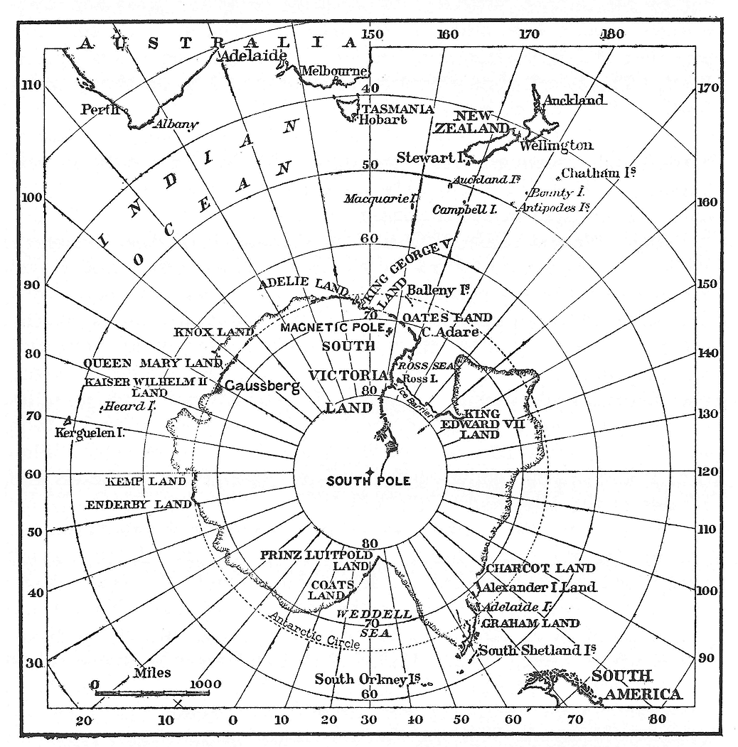
Robert Falcon Scott, in command of the Discovery Expedition, organised by the Royal Geographical Society and Royal Society with the co–operation of the Admiralty, in accordance with a scheme of international endeavour, passed two winters at the southern extremity of the Ross Sea and carried out many successful sledging journeys. Their main geographical achievements were: the discovery of King Edward VII Land; several hundred miles of new land on a ‘farthest south’ sledging journey to latitude 82° 17’ S; the discovery of the Antarctic plateau; additional details and original contributions to the geography of the lands and islands of the Ross Sea.
1901
A German national expedition, led by Erich von Drygalski, set out for the region south of the Indian Ocean. After a small party had been stationed on Kerguelen Island, the main party proceeded south close to the tracks of the Challenger. They came within sight of Antarctic shores but were frozen into the pack ice for a whole year. Kaiser Wilhelm II Land was discovered close to the junction between the Australian and African Quadrants.
1901
A Swedish national expedition, planned and led by Otto Nordenskjold, wintered for two years on Snow Hill Island in the American Quadrant, and did much valuable scientific work.
1902
William Speirs Bruce organized and led a Scottish expedition to the Weddell Sea, southward of the Atlantic Ocean. The party effected notable oceanographic researches and wintered at the South Orkney Islands, but were foiled in their attempt to penetrate the pack ice. During the second season, conditions were more favourable and the ship reached Coats Land in 74° 1’ S latitude.
1903
Jean Charcot organized and led a French expedition to the American Quadrant and there added many details to the existing chart.
1907
Ernest Henry Shackleton organized and led a British expedition with the main object of reaching the South Geographical Pole. His party wintered at Cape Royds, McMurdo Sound, and two main sledging parties set out in the early summer. EH Shackleton’s party ascended the Antarctic plateau and penetrated to within ninety seven geographical miles of the South Pole, discovering new land beyond Scott’s ‘farthest south’. TW Edgeworth David’s party reached the South Magnetic Polar Area, filling in many details of the western coast of McMurdo Sound.
1908
Jean Charcot organized and led a second French expedition to extend the work accomplished in 1903 in the American Quadrant. He was successful in discovering new land still further to the south. Loubet, Fallieres and Charcot Lands, towards and beyond Alexander I Land, were added to the map of Antarctica.
1910
Roald Amundsen organized an expedition for scientific research in the vicinity of the North Pole but changed his plans, eventually heading for the South Pole. The expedition wintered on the Ross Barrier near King Edward VII Land, from which point he set out and attained the South Geographical Pole, mapping in new land on the way. Another party visited King Edward VII Land.
1910
Robert Falcon Scott led a second Antarctic expedition, the main object of which was to reach the South Geographical Pole. The principal party wintered near his old winter quarters at Hut Point, McMurdo Sound. A second party was landed at Cape Adare. Scott reached the Pole soon after the Norwegian Amundsen, but he and his party perished on the return journey. Other parties added details to the map of Victoria Land. Oates Land was sighted from the ship to the westward of Cape Adare in the Australian Quadrant.
1910
A Japanese expedition sailed to the Ross Sea, but on account of the lateness of the season was forced to turn back without landing. The winter was spent at Sydney, New South Wales. Next year a summer visit was made to the South, but no additional land discoveries were made.
1911
A German expedition, led by Wilhelm Filchner, proceeded to the Weddell Sea; the South Pole being its objective. The party succeeded in reaching further south in that region than any previous navigators and discovered new land, to be named Prince Luitpold Land. They were driven northwards amongst the pack in a blizzard and spent the winter frozen in south of Coats Land.