
It should be remarked that there is no intention of furnishing anything more than a suggestion of the general trend of the scientific observations of the Expedition. The brief statement made below indicates the broad lines on which the work was conducted and in some cases the ground which was actually covered. It may thus give the general reader a clue to the nature of the scientific volumes which will serve to record permanently the results amassed during a period of more than two years.
Terrestrial magnetism
1. Field work
- Dip determinations were made at Macquarie Island, on the eastern and southern journeys from the Main Base (Adélie Land) and on a short journey from the Western Base (Queen Mary Land).
- Declination by theodolite observations was determined at Macquarie Island and at intervals on all sledging journeys in the Antarctic.
- Rough observations of magnetic variation were made daily on the Aurora during her five cruises.
2. Station work
- Regular magnetograph records were kept at the Main Base (Adélie Land) for a period of eighteen months. A system of term days for quick runs was also followed; Melbourne, Christchurch, and other stations co-operating. In connection with the magnetograph work, Webb conducted regular, absolute observations throughout the year 1912. Bage continued the magnetograph records for a further six months in 1913, observed term days, and took absolute observations.
- At the Western Base (Queen Mary Land) Kennedy kept term days in the winter, using a magnetometer and dip circle.
Biology
1. Station collections
- At Macquarie Island, Hamilton worked for two years amongst a rich fauna and a scanty but interesting flora. Amongst other discoveries a finch indigenous to Macquarie Island was found.
- In Adélie Land, Hunter, assisted by Laseron, secured a large biological collection, notwithstanding the continuous bad weather. Dredgings from depths down to fifty fathoms were made during the winter. The eggs of practically all the flying birds known along Antarctic shores were obtained, including those of the silver–grey petrel and the Antarctic petrel, which were not previously known; also a variety of prion, of an unrecorded species, together with its eggs.
- At the Western Base (Queen Mary Land) eggs of the Antarctic and other petrels were found, and a large rookery of Emperor penguins was located; the second on record. Harrisson, working under difficulties, succeeded in trapping some interesting fish on the bottom in two hundred and fifty fathoms of water.
2. Ship collections
- A collection made by Mr ER Waite, Curator of the Canterbury Museum, on the first subantarctic cruise.
- A collection made by Professor TT Flynn, of Hobart, on the second subantarctic cruise.
- A collection made by Hunter, assisted by Hamilton, in Antarctic waters during the summer of 1913–1914. This comprised deep sea dredgings at eleven stations in depths down to one thousand eight hundred fathoms and regular tow–nettings, frequently serial, to depths of two hundred fathoms. Six specimens of the rare Ross seal were secured. A large collection of external and internal parasites was made from birds, seals and fish.
Geology
- A geological examination of Macquarie Island was made by Blake. The older rocks were found to be all igneous. The Island has been overridden in comparatively recent times by an ice cap travelling from west to east.
- Geological collections at the Main Base. In Adélie Land the rocky outcrops are metamorphic sediments and gneisses. In King George V Land there is a formation similar to the Beacon sandstones and dolerites of the Ross Sea, with which carbonaceous shales and coaly strata are associated.
- Stillwell met with a great range of minerals and rocks in the terminal moraine near Winter Quarters, Adélie Land. Amongst them was red sandstone in abundance, suggesting that the Beacon sandstone formation extends also throughout Adélie Land but is hidden by the ice–cap. A solitary stony meteorite was found by a sledging party lying on the ice of the plateau.
- In the collections made by Watson and Hoadley at the Western Base (Queen Mary Land) gneisses and schists were ascertained to be the predominant types.
- A collection of erratics was brought up by the deep sea trawl in the course of dredgings in Antarctic waters.
Glaciology
- Observations of the pack ice, coastal glaciers and shelf ice from the Aurora during her three Antarctic cruises.
- Observations of the niveous and glacial features met with on the sledging journeys from both Antarctic bases.
Meteorology
- Two years’ observations at Macquarie Island by Ainsworth.
- Two years’ observations in Adélie Land by Madigan.
- One year’s observations in Queen Mary Land by Moyes.
- Observations by the Ship on each of her five voyages.
- Observations during the many sledging journeys from both Antarctic Bases.
Bacteriology, etc
In Adélie Land, McLean carried out many months of steady work in Bacteriology, Haematology and Physiology.
Tides
Self–recording instruments were run at Macquarie Island by Ainsworth and at Adélie Land by Bage.
Wireless and auroral observations
A very close watch was kept upon auroral phenomena with interesting results, especially in their relation to the permeability of the ether to wireless waves.
Geographical results
- The successful navigation by the Aurora of the Antarctic pack ice in a fresh sphere of action, where the conditions were practically unknown, resulting in the discovery of new lands and islands.
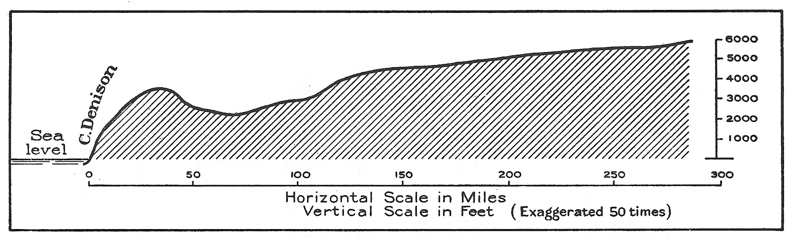
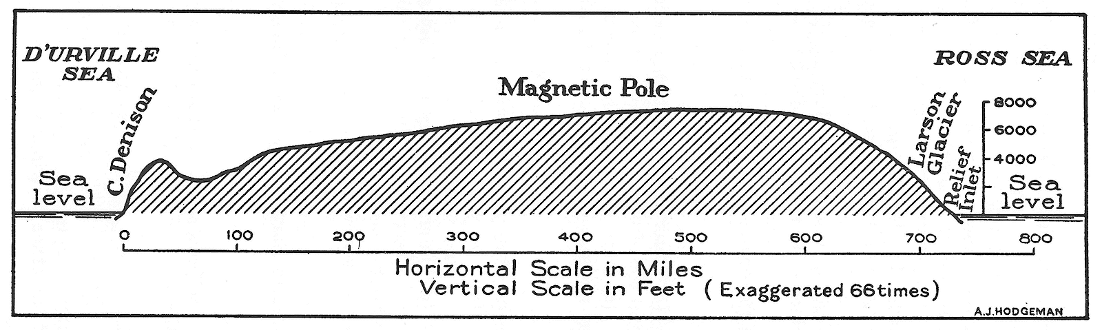
- Journeys were made over the sea ice and on the coastal and upland plateau in regions hitherto unsurveyed. At the Main Base (Adélie Land) the journeys aggregated two thousand four hundred miles, and at the Western Base (Queen Mary Land) the aggregate was eight hundred miles. These figures do not include depot journeys, the journeys of supporting parties, or the many miles of relay work. The land was mapped in through 33° of longitude, 27° of which were covered by sledging parties.
- The employment of wireless telegraphy in the fixation of a fundamental meridian in Adélie Land.
- The mapping of Macquarie Island.
Oceanography
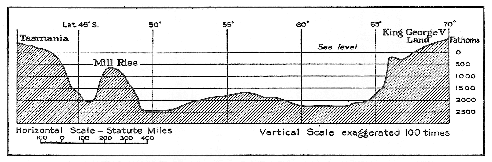
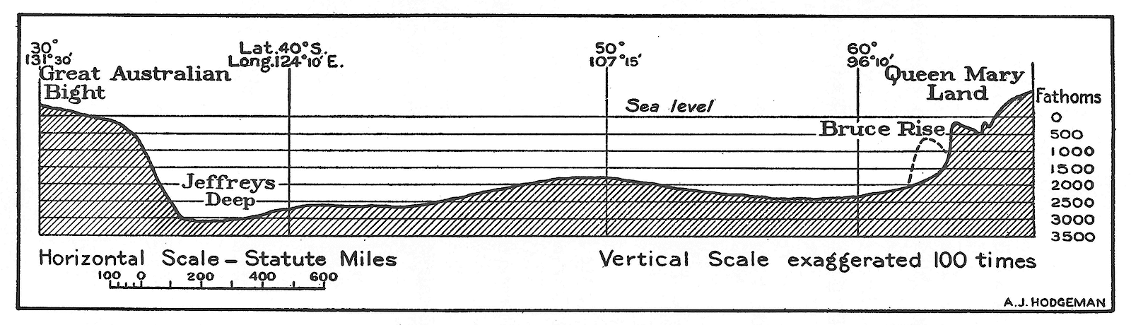
- By soundings the fringe of the Antarctic Continent as well as the Continental Shelf has been indicated through 55° of longitude.
- The configuration of the floor of the ocean southward of Australia and between Macquarie Island and the Auckland Islands has been broadly ascertained.
- Much has been done in the matter of seawater temperatures and salinities.