
Project information
Project aim
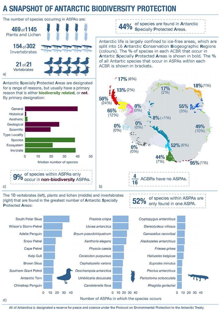
The Environmental Protocol to the Antarctic Treaty requires the identification of areas to be protected for their outstanding values. The Protocol lists values that may warrant protection but offers little guidance on criteria for inclusion or for deciding the location and size of protected areas. General principles of spatial conservation planning are now well developed globally, but as yet have not been systematically applied to the Antarctic region. This project will provide an evidence-based, spatially explicit foundation for protected area designation. It will take explicit account of the special characteristics of Antarctic biodiversity and landscapes, including how these values might change in the future. The research will culminate in a proposal for a set of Antarctic Specially Protected Areas, within a systematic environmental-geographical framework, that will provide comprehensive and ongoing protection for important areas of Antarctic terrestrial and nearshore biodiversity.
Project milestones
Summary of the project achievements 2019/20
This project has provided the foundation for further developing area protection across Antarctica and changed the way scientists and policy makers view area protection across the region. Key outputs include 11 published papers, seven submissions to the Antarctic Treaty Consultative Meetings and the most comprehensive database of Antarctic biodiversity ever compiled for terrestrial Antarctica. These outputs have also underpinned a range of advice that has informed Australia's position at international meetings, including the Antarctic Treaty System's Committee for Environmental Protection. Outcomes include more efficient and targeted acquisition of continent wide data sets, a better and more thorough understanding of the spatial elements that can inform spatial protection and compelling evidence of the importance of systematic conservation planning in developing a systematic protected area network in Antarctica.
Summary of the season 2018/19
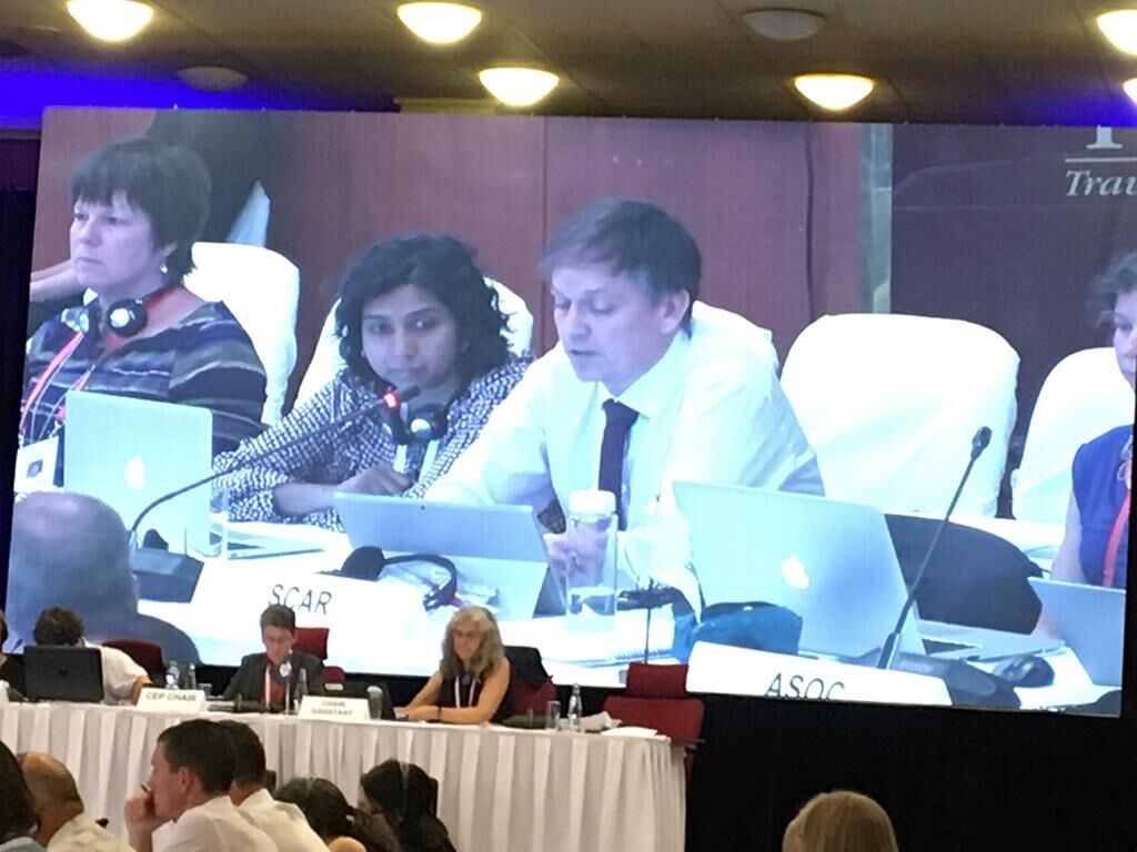
This project represents a multi-institutional and international collaborative effort to provide the evidence base to underpin the development and designation of protected areas in terrestrial and nearshore Antarctica. Over the past 12 months we have continued to publish our findings in high quality international peer-reviewed journals, provide advice to the Strategies Branch of the Australian Antarctic Division, contribute to submissions to the Antarctic Treaty System's Committee for Environmental Protection and finalize the Antarctic terrestrial biodiversity database, which has now been submitted to the Australian Antarctic Data Centre. A major achievement of this project for 2019 was the successful organisation of a major international workshop on 'Further developing the Antarctic Protected Area System', held in Prague in June 2019. The recommendations from this workshop were endorsed by the CEP and we are now working with national and international collaborators to progress a systematic conservation planning case study for terrestrial Antarctica.
Summary of the season 2017/18
This project represents a multi-institutional and international collaborative effort to provide the evidence base to underpin the development and designation of protected areas in terrestrial and nearshore Antarctica. Over the past 12 months we have completed all remaining desktop analyses planned for the project. Spatial layers underpinning the habitat analyses were revised, increasing the resolution from 10 km to 1 km and terrestrial Antarctica habitats have now been delineated on this scale for the entire continent. Continent wide species distribution models have been developed for over thirty taxonomic groups and analyses is now complete. Detailed and comprehensive taxonomic cross-referencing of the Antarctic Biodiversity Database has also been completed; final checks are now underway in preparation of this database for public release. These components all represent foundational elements for progressing the development of a systematic protected area system in Antarctica. Spatial layers associated with these aspects have been submitted to the Australian Antarctic Data Centre. We are now working with national and international colleagues to convene a workshop to bring together scientists and policy-makers in 2018-19, to further facilitate the progression of protected area development through the Antarctic Treaty System.
Summary of the season 2016/17
This project represents a multi-institutional and international collaborative effort to provide the evidence base to underpin the development and designation of protected areas in terrestrial and nearshore Antarctica. Substantial progress has been made on this project since the last milestone report. Another 3,000 + new records have been added to the biodiversity database which has reached the first stage of completion and has been submitted to the Australian Antarctic Data Centre. This database now holds over 48,000 biodiversity records and represents the largest biodiversity database ever assembled for terrestrial Antarctica. Other outputs include three scientific research papers published in high-profile international scientific journals, one Working Paper and two Information Paper that have been prepared for submission to the 2017 meeting of the Antarctic Treaty System's Committee on Environmental Protection. Analyses on Antarctic habitat delineations has been completed, and models of Antarctic biodiversity have progressed and are currently being prepared for submission for publication. In collaboration with the British Antarctic Survey, predictions of Antarctic temperatures and precipitation have been developed for the entire continent, and the acquisition of other spatial layers has been completed and submitted to the Australian Antarctic Data Centre.
Summary of the season 2015/16
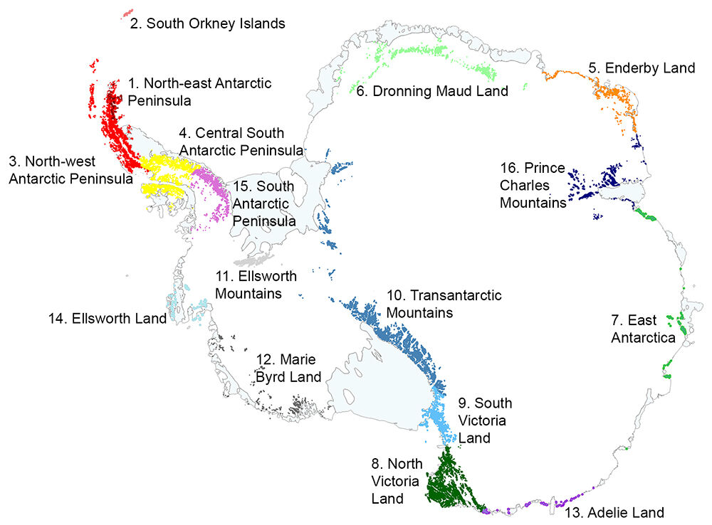
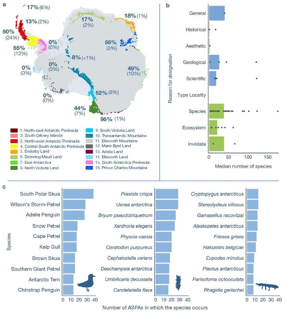
This project represents a multi-institutional and international collaborative effort to provide the evidence-base to underpin the development and designation of protected areas in terrestrial and nearshore Antarctica. Considerable progress has been made towards achieving the priority objectives of the project since it was approved in July 2015. Initial efforts focused on adding more biodiversity data to the Antarctic Biodiversity Database and acquiring and developing a range of spatial layers. The former has involved the digitisation of biodiversity records from over 250 publications, adding over 7000 records to to the biodiversity database. The spatial layers have been acquired from a diverse range of sources, and a number of derived layers have now also been compiled. The spatial layers include a high resolution, continent-wide temperature layer (and derived degree days), improved solar radiation layer (also on a continent scale), refined terrain roughness layer, cloud cover and wind speed. Major outputs since August 2015 include a comprehensive data management plan for the project and a revision of the Antarctic Conservation Biogeographic Regions (ACBRs) recently accepted for publication by the journal Diversity and Distributions. The latter publication also provides an analysis of the connectivity and patchiness of the ice-free areas of Antarctica, as well as a new set of summary statistics for a range of metrics, including climate, area protection and human activity. Analyses are well underway to delineate and clarify habitat characteristics of ice-free Antarctica and better understand the links between the physical and biological environments.