
Project information
Project aim
This research project addresses the question of Antarctic mass balance change by mining publicly accessible geodetic databases and assimilating existing terrestrial and space based geodetic observations collected on and around the Antarctic continent over the last decade. The result will be estimates of Antarctic mass balance change consistent with all of the available historic physical and geometric measurements of the continent. This project relates to the key research question - "What is the present state and rate of change of Antarctic ice mass"
Project milestones
Summary of the project achievements 2014/15
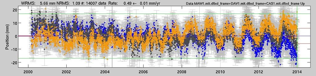
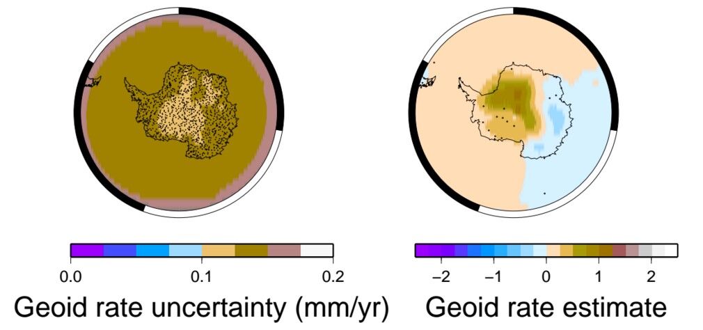
At present, global sea level is rising at around 3 mm/yr, as measured by satellite altimetry and a discrete set of tide gauges. The increases in sea surface heights are caused by a number of factors as thermal expansion of the oceans, salinity changes and the transfer of water from the continents to the oceans, consequence of melting of glaciers and ice caps. To enable accurate predictions of what future sea levels the world may experience, we have to quantify the rate of present day melting of the Antarctic ice sheet, representing the largest volume of ice that could participate to sea level rise. To do this, scientists use space geodetic observations from satellite altimetry (e.g. Envisat, ICESat, Cryosat-2), GPS measurements (Global Positioning System) and space gravity (e.g. the Gravity Recovery and Climate Experiment mission, known as 'GRACE'), respectively. The altimetric approach enables measurement of the ice thickness and topography, the GPS measurements the change in height from a rock site, whereas the latter is used to 'weigh' Antarctica and derive the mass balance changes. These observation types sense not only present-day changes in the ice sheet but also the ongoing response of the Antarctic continent to the melting of the ice sheet that occurred thousands of years ago (known as Glacial Isostatic Adjustment or 'GIA'). Thus, in order to use these space geodetic observations to estimate present-day mass balance, it is necessary to first separate the GIA signals from the mass balance change signals. Do to this, we undertook research to determine if a simultaneous inversion of various geodetic data types could be used to separate the comingled GIA and loading signals. We used a combination of simulated data (Ocean Bottom Pressure, GPS, Grace measurements and ICESat altimeter data) to separate the GIA from other signals. The computations were done with different a priori values (starting values) and data noise characteristics and regularisations (smoothing
Summary of the season 2013/14
At present, global sea level is rising at around 3 mm/yr, as measured by satellite altimetry and a discrete set of tide gauges. The increases in sea surface heights are caused by a number of factors as thermal expansion of the oceans, salinity changes and the transfer of water from the continents to the oceans, consequence of melting of glaciers and ice caps. To enable accurate predictions of what future sea levels the world may experience, we have to quantify the rate of present day melting of the Antarctic ice sheet, representing the largest volume of ice that could participate to sea level rise. To do so, scientists use space geodetic observations from satellite altimetry (e.g. Envisat, ICESat, Cryosat-2), GPS measurements (Global Positioning System) and space gravity (e.g. the Gravity Recovery and Climate Experiment mission, known as 'GRACE'), respectively. The altimetric approach enables measurement of the ice thickness and topography, the GPS measurements the change in height from a rock site, whereas the latter is used to 'weigh' Antarctica and derive the mass balance changes. These observation types sense not only present-day changes in the ice sheet but also the ongoing response of the Antarctic continent to the melting of the ice sheet that occurred thousands of years ago (known as Glacial Isostatic Adjustment or 'GIA'). Thus, in order to use these space geodetic observations to estimate present-day mass balance, it is necessary to first separate the GIA signals from the mass balance change signals. Do to so, we developed a simultaneous inversion of geophysic data method. We used a combination of simulated data (Ocean Bottom Pressure, GPS, Grace measurements and ICESat altimeter data) to separate the GIA from other signals. The computation has been done with different apriori to assess a proper GIA estimate. The next step will be to use real observables processed at RSES.
Summary of the season 2012/13
Modern geodetic techniques enable precise measurements of the Earth's time variable geometric shape and gravity field as it responds to mass balance changes. Our work will assimilate a range of geodetic observations to determine the present day mass balance changes occurring in Antarctica. We have made progress on identifying existing geodetic data sets collected on and around Antarctica, including GNSS measurements, space gravity observations and satellite altimetry. We have commenced analysing the Antarctic data sets identified using data processing methods we have developed over the last decade and are continuing to refine. We have produced some preliminary time series estimates of solid Earth deformation, gravity field changes, ice surface elevation fluctuations on and around Antarctica. In the near future we will begin to assimilate the reprocessed geodetic time series to constrain quantitative models of the Antarctic's recent mass balance changes.
Related publications
-
Ice Height Change in East Antarctica derived from Satellite Altimetry PhD Thesis, Australian National University, Australia, 2016
(Ref: 15962)
Authors:Category 3: Thesis, higher degree
-
Interannual variation of the Antarctic Ice Sheet from a combined analysis of satellite gravimetry and altimetry data Earth and Planetary Science Letters, 2015
(Ref: 15963)
Category 1: Peer-reviewed literature
-
An assessment of the ICE6G C (VM5A) glacial-isostatic adjustment model EGU General Assembly 2016, Vienna, Austria, 17-22 April 2016, 2016
(Ref: 15964)
Authors:Category 3: Verbal presentation
-
Comparison of observations and modelling of surface mass balance variations in East Antarctica PhD Thesis, Australian National University, Australia, 2016
(Ref: 15937)
Authors:Category 3: Thesis, higher degree