

Project information
Project aim
This project explores ice sheet structure, Antarctic bedrock and changing ice volume to answer key questions about Antarctica and current and future sea-level rise.
Project milestones
Summary of the project achievements 2017/18
The airborne surveys conducted in Antarctica, and the associated analysis and interpretation of data conducted by AAS 4077 (ICECAP) has provided critical information on the geometry of the East Antarctic ice sheet. Such information is necessary to assess the long term stability of the ice sheet, and its vulnerability to changing ocean conditions. Data from ICECAP over broad swathes of the Australian Antarctic Territory were included into the Bedamp2 data compilation, which has enabled over 700 studies into the current state and future evolution of the Antarctic ice sheet.
A key finding from AAS 4077 (ICECAP) was a greater understanding of the sensitivity and rapid response time of key East Antarctic glaciers to changing heat oceanic heat delivery underneath ice shelves and glacier tongues. In particular, the Totten Glacier and its catchment has the potential for in excess of 3.5m of global sea-level change and the ICECAP collaboration has shown that
- over geological time-scales, the Totten Glacier catchment has retreated several hundred kilometres inland on multiple occasions, and that these retreats have been rapid
- there is a pathway for warm water to penetrate deep under the floating portion of the Totten Glacier
- the geometry of the bedrock and ice shelf near the deep grounding line of the Totten Glacier is such that ice velocities are sensitive to changes in the oceanic heat entering the cavity beneath the floating portion of the Totten Glacier
Together these insights have lead to an evolution of the ICECAP project (through AAS 4346 ICECAP II and the proposed AAS 4511 ICECAP EAGLE) to focus more strongly on the ocean state and pathways for warm water to cross the continental shelf and circulate beneath ice shelves and glacier tongues.
Summary of the season 2016/17
ICECAP continued to analyse existing data, publishing three and submitting an additional papers in high impact, peer reviewed scientific journals. Two recent post-doctoral researchers appointed through the ARC Antarctic Gateway Partnership are directly working on ICECAP data streams, leading to improved estimates of the geothermal heat flux heating the ice sheet from below, and better computer models of the evolution of the Antarctic ice sheet into the future. A PhD candidate has been recruited to work on the geothermal flux estimates.
Summary of the season 2015/16
ICECAP continued to analyse existing data, producing 4 papers in high impact, peer reviewed scientific journals and an additional paper submitted. Two recent post-doctoral researchers appointed through the ARC Antarctic Gateway Partnership are directly working on ICECAP data streams, leading to improved estimates of the geothermal heat flux heating the ice sheet from below, and better computer models of the evolution of the Antarctic ice sheet into the future.
Summary of the season 2014/15
Due to adverse weather conditions, no survey flights were possible in the 2014/15 field season. ICECAP continued to analyse existing data, producing 4 papers in high impact, peer reviewed scientific journals. Two recent post-doctoral researchers appointed through the ARC Antarctic Gateway Partnership will be directly working on ICECAP data streams, leading to improved estimates of the geothermal heat flux heating the ice sheet from below, and better computer models of the evolution of the Antarctic ice sheet into the future.
Summary of the season 2012/13
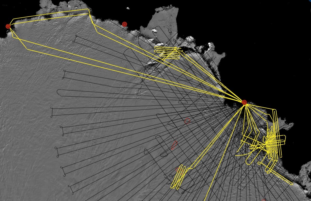
The ICECAP project's 2012 operations in East Antarctica included 16 flights, and collected 13,320 nautical miles (24668 km) of science data. Science highlights include:
1. extending the mapping of ice thickness and surface elevation of the East Antarctic grounding zone from Casey to Davis Stations
2. comprehensive gravity mapping of the entrance to the ocean cavity beneath the Totten Glacier cavity,
3. lidar reflights of ICESat and ICECAP tracks over Totten and Denman glaciers to study ice sheet change
5. new lidar baselines along the grounding zone of Moscow University Ice Shelf
4. survey of a critical junction in subglacial hydrology in the Aurora Subglacial Basin
Related publications
-
Gravity-derived Antarctic bathymetry using the Tomofast-x open-source code: a case study of Vincennes Bay The Cryosphere, 2025
(Ref: 17370)
Authors:Category 1: Peer-reviewed literature
Vincennes Bay is a region of East Antarctica vulnerable to sub-ice shelf basal melting from warm ocean water intrusions. The sub-ice shelf bathymetry in this region is largely unknown, despite its importance for ocean dynamics within ice shelf cavities and associated sub-ice shelf basal melting.
-
Bedmap3 updated ice bed, surface and thickness gridded datasets for Antarctica Scientific Data, 2025
(Ref: 17227)
Authors:Pritchard H.D.Fretwell P.T.Frémand A.C.Bodart J.A.Kirkham J.D.Aitken A.Bamber J.Bell R.Bianchi C.Bingham R.G.Blankenship D.D.Casassa G.Christianson K.Conway H.Corr H.F.J.Cui X.Damaske D.Damm V.Dorschel B.Drews R.Eagles G.Eisen O.Eisermann H.Fausto F.Field E.Forsberg R.Franke S.Goel V.Gogineni S.P.Greenbaum J.Hills B.Hindmarsh R.C.A.Hoffman A.O.Holschuh N.Holt J.W.Humbert A.Jacobel R.W.Jansen D.Jenkins A.Jokat W.Jong L.Jordan T.A.King E.C.Kohler J.Krabill W.Maton J.Gillespie M.K.Langley K.Lee J.Leitchenkov G.Leuschen C.Luyendyk B.MacGregor J.A.MacKie E.Moholdt G.Matsuoka K.Morlighem M.Mouginot J.Nitsche F.O.Nost O.A.Paden J.Pattyn F.Popov S.Rignot E.Rippin D.M.Rivera A.Roberts J.L.Ross N.Ruppel A.Schroder D.M.Siegert M.J.Smith A.M.Steinhage D.Studinger M.Sun B.Tobacco I.Tinto K.J.Urbini S.Vaughan D.G.Wilson D.S.Young D.A.Zirizzotti A.Category 1: Peer-reviewed literature
We present Bedmap3, the latest suite of gridded products describing surface elevation, ice-thickness and the seafloor and subglacial bed elevation of the Antarctic south of 60?°S. Bedmap3 incorporates and adds to all post-1950s datasets previously used for Bedmap2…
-
Antarctic Bedmap data: Findable, Accessible, Interoperable, and Reusable (FAIR) sharing of 60 years of ice bed, surface, and thickness data. Earth System Science Data, 2023
(Ref: 17072)
Authors:Frémand A.C.Fretwell P.Bodart J.A.Pritchard H.D.Aitken A.Bamber J.L.Bell R.Bianchi C.Bingham R.G.Blankenship D.D.Casassa G.Catania G.Christianson K.Conway H.Corr H.F.J.Cui X.Damaske D.Damm V.Drews R.Eagles G.Eisen O.Eisermann H.Ferraccioli F.Field E.Forsberg R.Franke S.Fujita S.Gim Y.Goel V.Gogineni S.P.Greenbaum J.Hills B.Hindmarsh R.C.A.Hoffman A.O.Holmlund P.Holschuh N.Holt J.W.Horlings A.N.Humbert A.Jacobel R.W.Jansen D.Jenkins A.Jokat W.Jordan T.King E.Kohler J.Krabill W.Kusk Gillespie M.Langley K.Lee J.Leitchenkov G.Leuschen C.Luyendyk B.MacGregor J.MacKie E.Matsuoka K.Morlighem M.Mouginot J.Nitsche F.O.Nogi Y.Nost O.A.Paden J.Pattyn F.Popov S.V.Rignot E.Rippin D.M.Rivera A.Roberts J.Ross N.Ruppel A.Schroeder D.M.Siegert M.J.Smith A.M.Steinhage D.Studinger M.Sun B.Tabacco I.Tinto K.Urbini S.Vaughan D.Welch B.C.Wilson D.S.Young D.A.Zirizzotti A.Category 1: Peer-reviewed literature
One of the key components of this research has been the mapping of Antarctic bed topography and ice thickness parameters that are crucial for modelling ice flow and hence for predicting future ice loss and the ensuing sea level rise. Supported by the Scientific Committee on Antarctic Research (SCAR)…
-
The impact of variable ocean temperatures on Totten Glacier stability and discharge Geophysical Research Letters, 2021
(Ref: 16415)
Category 1: Peer-reviewed literature
-
A detailed radiostratigraphic data set for the central East Antarctic Plateau spanning from the Holocene to the mid-Pleistocene Earth Systems Science Data, 2021
(Ref: 16545)
Category 1: Peer-reviewed literature