
Camera equipment used for nearly two decades to capture aerial images of Australia’s Antarctic territory and its subantarctic islands has been donated to the Tasmanian Museum and Art Gallery.
The two film cameras and a GPS unit were used by the Australian Antarctic Division to take aerial photographs for large scale mapping and for penguin and seal counts. The maps generated from these photographs are still used today for station and field operations, including field trips, aviation and management of the station environs.
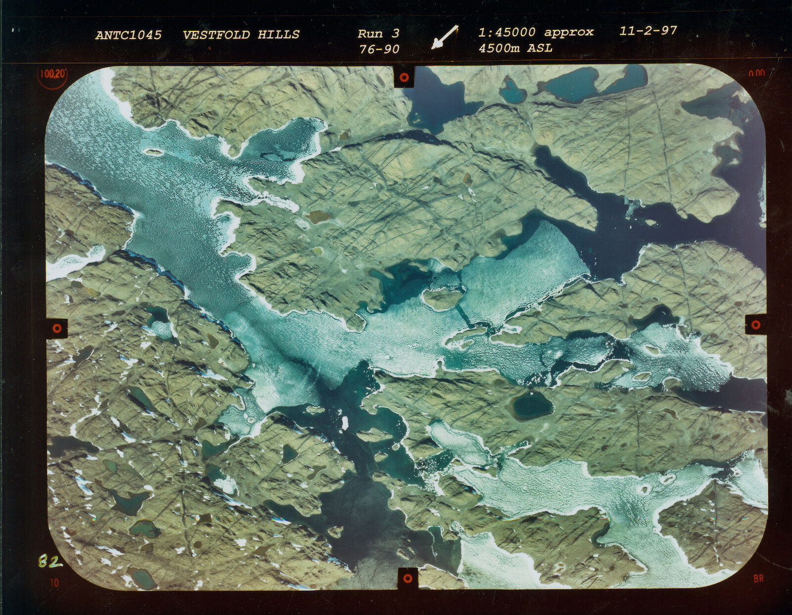
The first camera, a Zeiss UMK1318 ‘metric’ or mapping camera, was deployed in helicopters from 1993 to 2003, primarily to photograph the Windmill Islands, Vestfold Hills, Larsemann Hills, Holme Bay, Framnes Mountains, northern Macquarie Island, and the buildings and services at Australia’s Antarctic stations. The camera operated alongside an Ashtech Z-12 GPS unit, used to record the coordinates of each photograph.
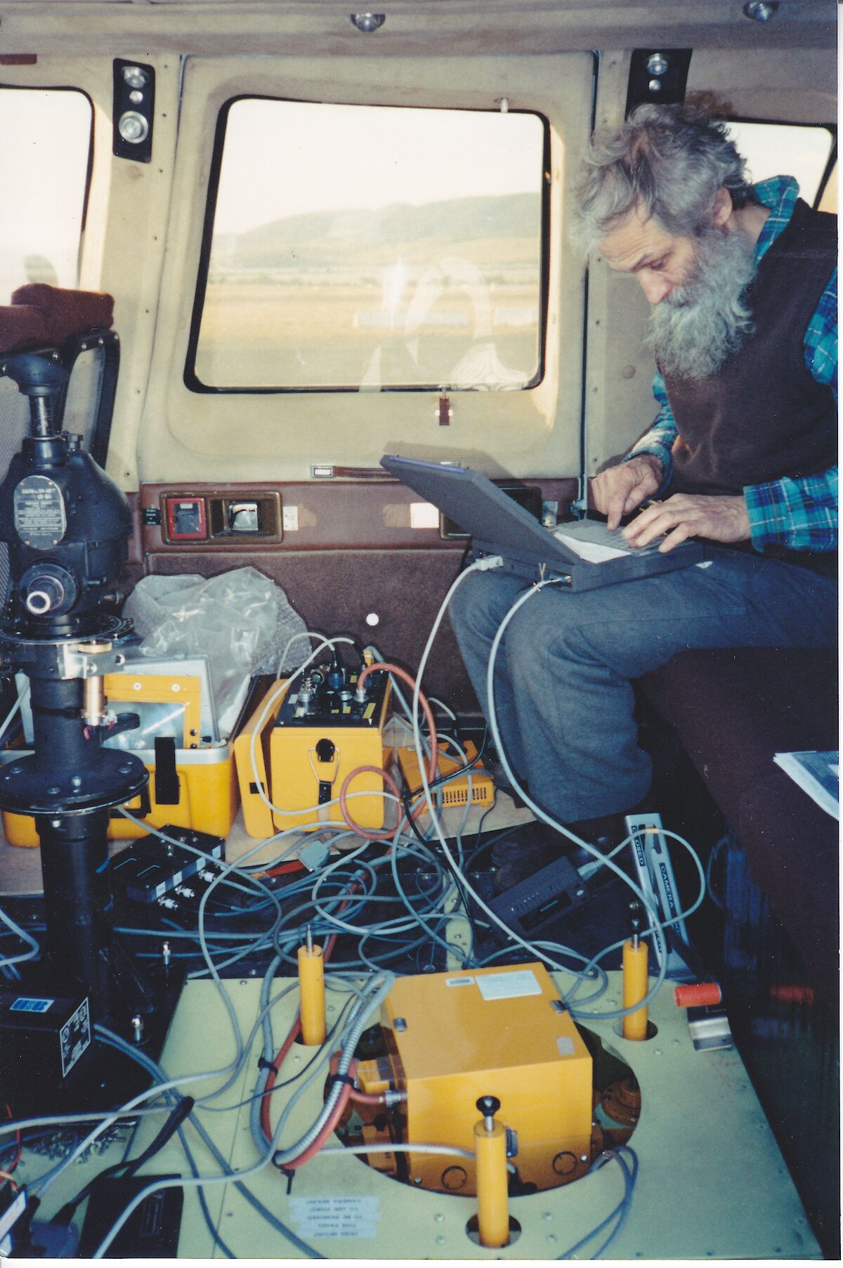
Engineer, Roger Handsworth, installed the camera in the Squirrel and Sikorsky helicopters used by the Division, and modified or built equipment to enhance the camera’s use.
‘We stored flight plans in a flight navigation program on a laptop computer and these plans would appear on screen as lines, with the coordinates for each photo that we wanted to take displayed as little circles,’ Roger said.
‘We had the GPS feeding into the computer as well, so that when the pilot flew through a circle in the flight plan, the computer would trigger the camera controller, which would then fire the camera and advance the film.’
Roger acted as the aerial photography coordinator on many flights over the decade, alongside a pilot and a surveyor, clocking up some 411 flight lines, with each line recording many photographs. Most photos were taken at 10 000 ft (3000m) with an occasional venture to 15 000 ft (4500m), with oxygen. The aerial photos were taken with a degree of forward and side overlap so that they could be matched for mapping purposes later.
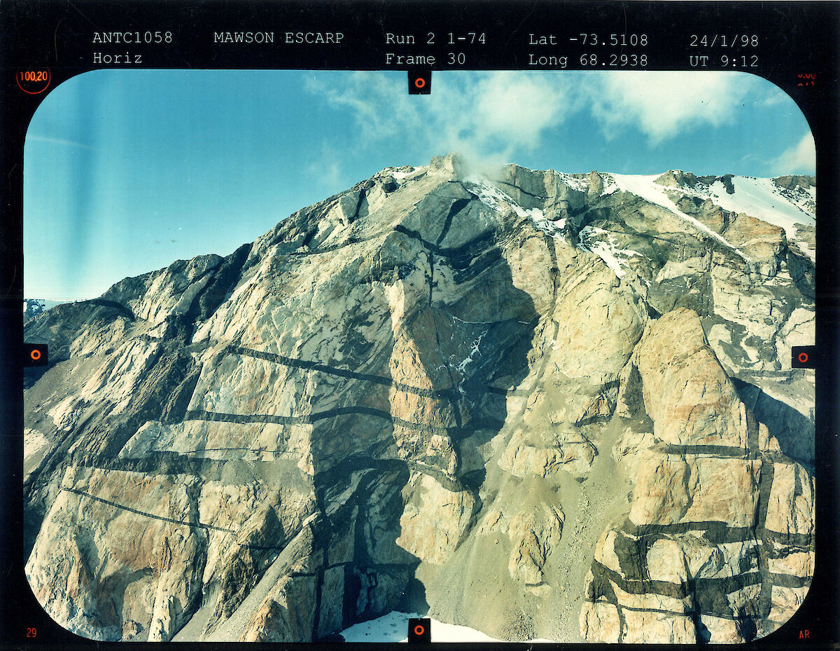
While most photos were taken from a position underneath the helicopter, on one occasion Roger built a camera stand that allowed the camera to be positioned at a horizontal angle out the helicopter window, to photograph the Mawson Escarpment — a precipitous ridge of rock towering up to 1000m above the Amery Ice Shelf.
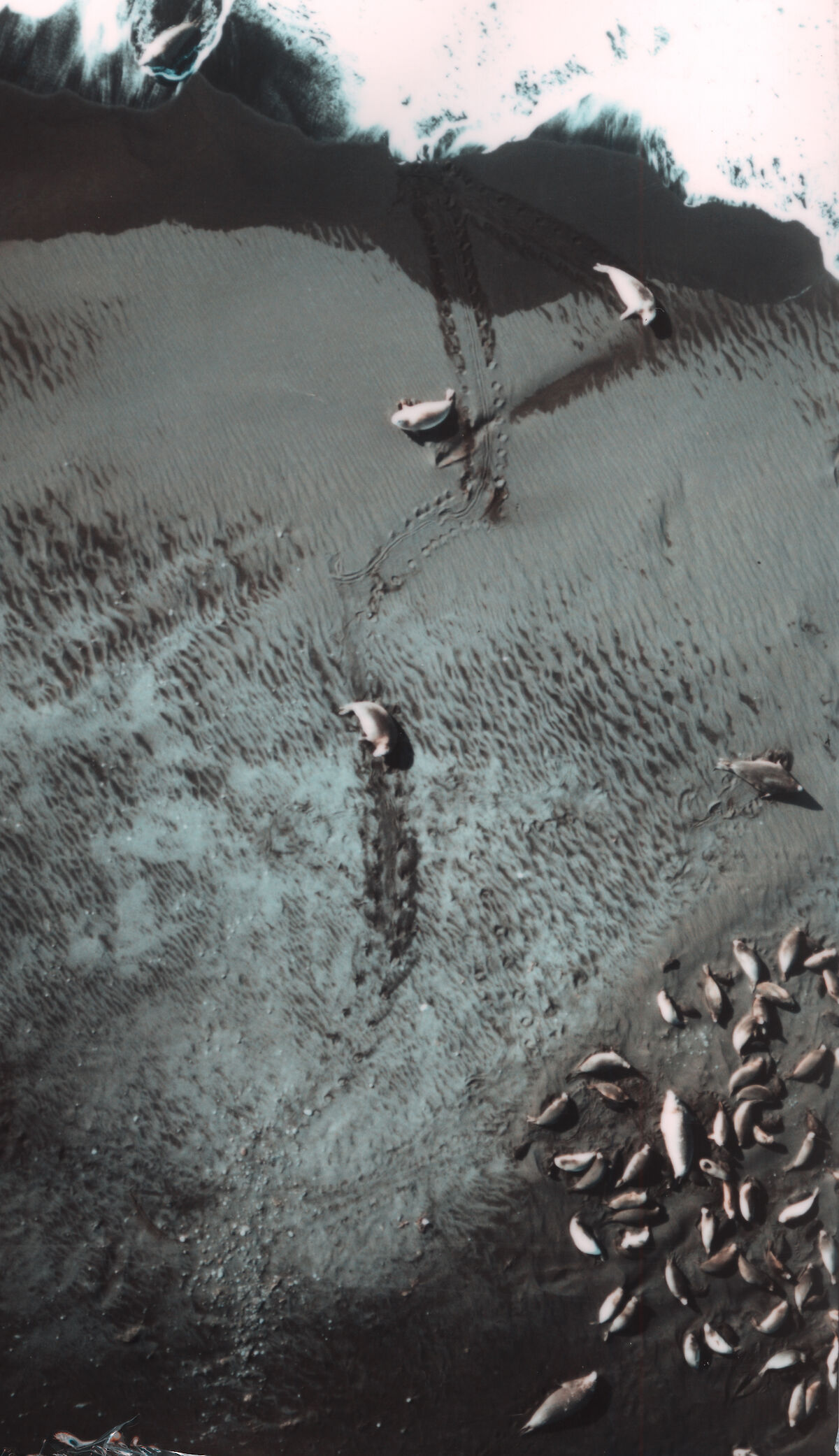
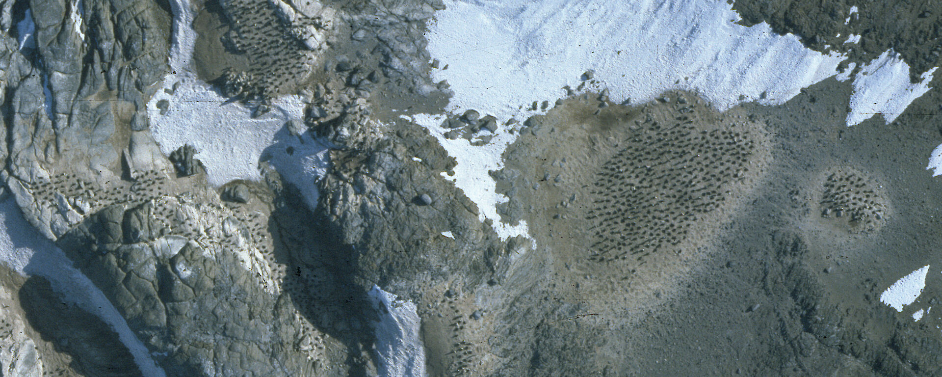
The second camera, a Linhof Aerotronica 69, was deployed in helicopters from 1986 to 2000 to take low altitude aerial photographs of seal and penguin colonies, and lakes. It was used at the Windmill Islands, Vestfold Hills, Heard Island, Larsemann Hills, Mawson Coast and Rauer Group of islands, across some 600 flight lines.
From an altitude of 500m and 750m, the camera’s 175mm telephoto lens provided high resolution images that were used by biologists to count emperor and Adélie penguins and elephant seals.
In the early 2000s, film cameras began to be replaced with digital cameras and satellite images.
Former Australian Antarctic Division Mapping Officer, Henk Brolsma, who organised the donation of the cameras to the museum, said changes in technology have reduced costs in some cases, but also required new approaches.
‘Since our last aerial photography flight, high resolution satellite imagery with a resolution of 0.5m has made it more efficient and cost-effective to derive geographic information suitable for producing 1:25 000 maps,’ he said.
‘However, satellite imagery is still not suitable for mapping stations or counting animal populations, and a new digital aerial camera capable of capturing imagery at the resolution of the Zeiss camera costs about $1 million and requires a fixed-wing aircraft set up for that purpose.
‘The way of the future is to use drones with suitable cameras and airborne scanners, technicians with a “flying” licence and the ability to process the imagery and scanner data.’
Mr Brolsma is pleased that an important part of Australia’s Antarctic history will be remembered through the Tasmanian museum’s collection.
‘The museum has a number of aerial cameras used in Antarctica in its collection, so it is fitting that these cameras become an integral part of that,’ he said.
‘They are probably the last film cameras to be used for aerial photography in the Australian Antarctic Territory, so it closes a chapter in the technology’s history.’
Wendy Pyper
Corporate Communications, Australian Antarctic Division