
In 2007–08 Mawson’s Huts Foundation expedition doctor, Tony Stewart, thought it would be interesting to see if he could find remnants of ‘Mawson’s air tractor’ — a Vickers monoplane used by the 1911–14 Australasian Antarctic Expedition. As a pilot and owner of a vintage aeroplane, he had an interest in aviation history. Searching for one of the early aeroplanes, and the very first to be taken to Antarctica, captured his imagination, time, enthusiasm and energy for the next three years.
I am not a pilot, nor an aviation enthusiast, but I am a scientist, engineer and doctor, and the search has also captured my time, enthusiasm and energy for the last two years. Eighteen months ago I went to Cape Denison with the Mawson’s Huts Foundation as the team doctor, and part of my job was to continue Tony’s search for the air tractor. We didn’t find it, but there was enough positive evidence to keep looking.
Last year (2008–09) I returned as the engineer to complete a number of projects including the air tractor search. Tony went as the team doctor and we combined our efforts to narrow down the location. Of course the aim was to find the frame, but time and weather were against us. We did, however, narrow down the options considerably and have put the team for 2010–11 in a good position to finish the search.
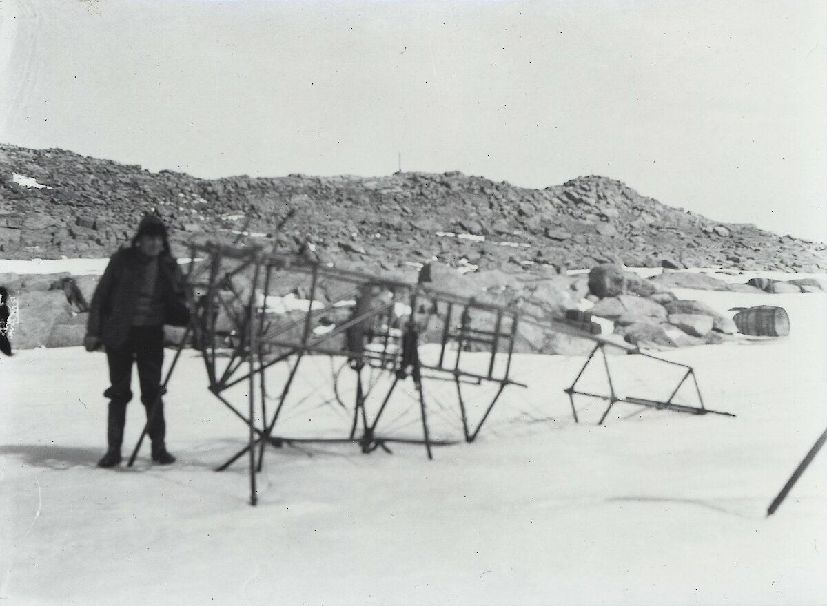
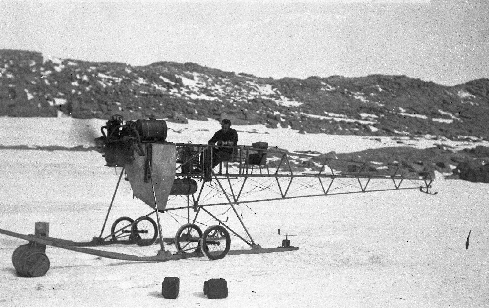
The Vickers monoplane was based on the R.E.P. 60 HP five-cylinder, air-cooled, semi-radial engine aircraft designed by Robert Esnault-Pelterie, a remarkable French inventor. The steel fuselage was built in France while the wings were made in England. After being tested at Vickers’ airfields at Dartford and Brooklands, it was crated and shipped to Australia for use by the Australasian Antarctic Expedition. Disaster fell when the wings were damaged beyond repair on 5 October 1911, during a practice flight in Adelaide.
The wings were removed and the machine was taken south, where Bickerton spent weeks converting the frame into an air tractor. Writing in the Home of the Blizzard after his return from Antarctica, Mawson said that the reason for taking the aircraft was more to attract publicity for the expedition’s cause rather than for its serious use in reconnaissance in the Antarctic.
The machine was tested on 15 November 1912, followed by a successful depot-laying trip with 700 pounds of supplies on 2 December. The next day the air tractor was taken on its first, and last, major trip. Bickerton wrote:
'While moving along, the idle cylinder was ejecting oil, and this, together with the fact that it had no compression, made me hope that broken piston-rings were the source of the trouble. It would only take two hours to remove three cylinders, take one ring from each of the two sound ones for the faulty one, and all might yet be well!
These thoughts were brought to a sudden close by the engine, without any warning, pulling up with such a jerk that the propeller was smashed. On moving the latter, something fell into the oil in the crank-case and fizzled, while the propeller could only be swung through an angle of about 30°. We did not wait to examine any further, but fixed up the man-hauling sledge, which had so far been carried by the air-tractor sledge, and cached all except absolute necessities.'
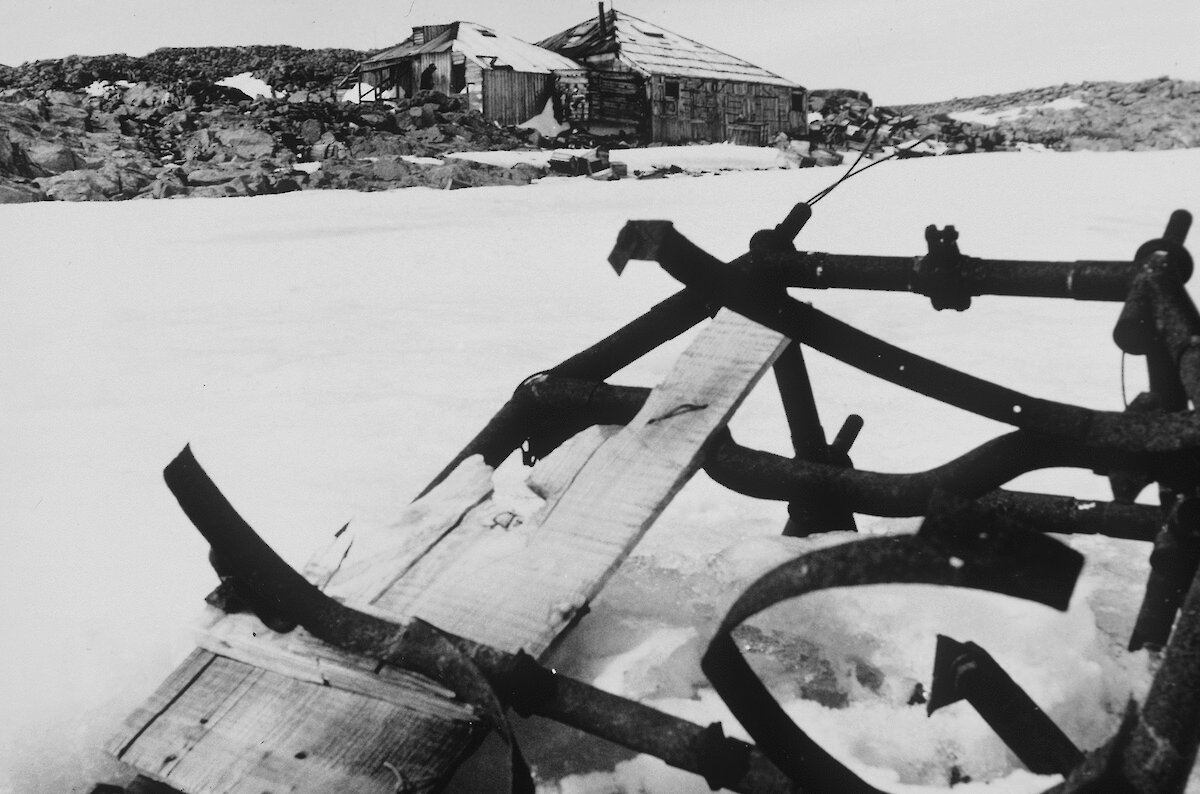
The air tractor never worked again, and the frame was abandoned on the shores of Boat Harbour when the Mawson expedition left in 1913. The engine, propeller and other items were removed before departure.
The frame remained on the ice for 63 years, before it disappeared. Bob Reeves, an Antarctic Division photographer, took the last photograph in 1976, showing all but 500 mm of the frame buried in the ice. By the next expedition in 1981, there was no frame. It seemed to me that the frame could not possibly have blown away (as some suggested), and the ice had been shown not to move, so the frame must have sunk in the ice. But photographs showed little sinking for about 60 years, so why had it disappeared between 1976 and 1981? A study of the continuous temperature records from Dumont d'Urville station (200 km away) showed that there was an extended period of high temperature in the years 1976 and 1981. Comparison between Cape Denison and Dumont d'Urville data showed the temperature could be up to 10 degrees higher at Cape Denison.Mawson’s reports indicated that the landscape can change very quickly in above zero temperatures. This was confirmed during the 2001 Mawson’s Huts Expedition, and our experience this year (2009–10) was the same — it only took three or four days of continuous above zero temperature and heavy rain for the surface ice near the harbour to turn to slush. The temperature records showed that in both 1976 and 1981 the temperature stayed high for about six weeks. This is long enough for a substantial melting of the ice, and I think that the frame sank in situ to the rock surface, three metres below the present ice surface. In fact, the results of our ice auger drilling are consistent with the hypothesis that a large area of ice at the harbour edge may have melted down to bedrock, taking the frame with it.
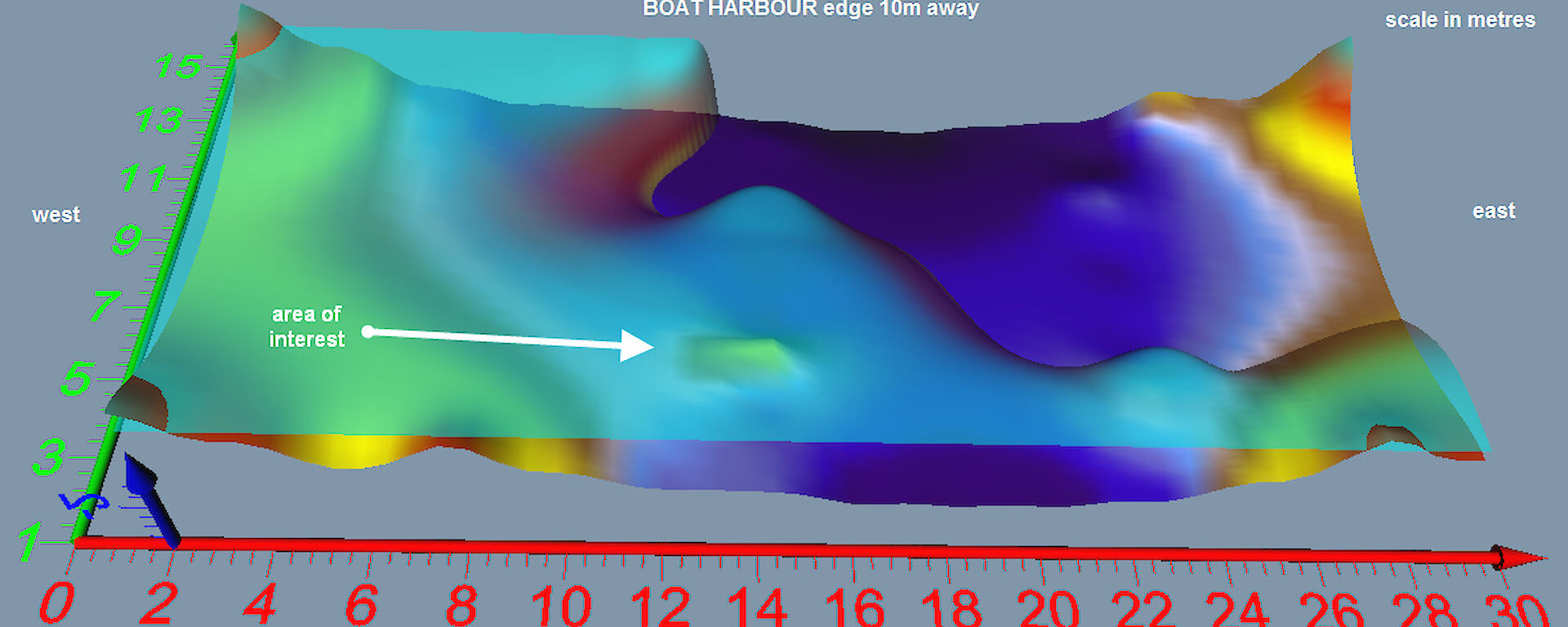
To accurately estimate the position of the air tractor, comparison was made between three historical photographs. Careful study of the pictures enabled three transits to be drawn, which crossed at one point on the ice. We are pretty sure that this is where the frame sank.
The plateau ice above and on either side of the Cape Denison area is constantly moving. However, there are no features of moving ice in the vicinity of the air tractor’s resting place, and discussion with glaciologists confirmed what Mawson said — the ice is stationary.
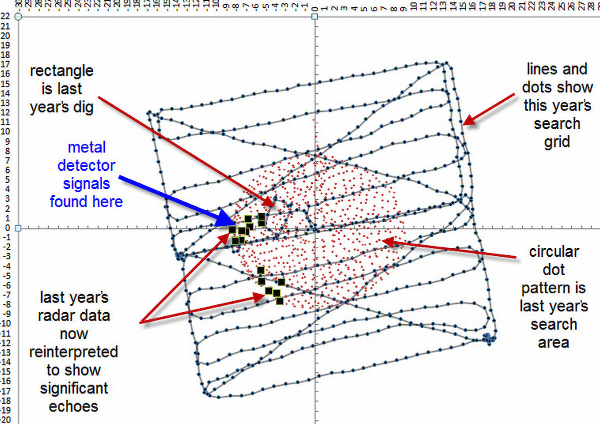
In 2009 I used ground penetrating radar to map the ice in the search area. I found an anomaly which looked significant, and we dug a 3m x 3m hole. We found nothing but a layer containing seaweed at around 2.5m. I came away from that expedition with a clear plan to find out more about the depth of the ice and the shape of the harbour floor, since we knew nothing of the detailed sub-surface structure. For example, there could have been a deep trench in the rock into which the frame sank — the only survey of the harbour up till then suggested this could have been the case.
This year I used differential GPS to accurately map the height of the ice; bathymetry equipment to map the harbour floor; and ice augers to map the rock levels in the search area. I found that the rocks under the ice are level with the harbour bottom.
This means that the rock under the search area is about 500mm below tide datum, and therefore 1500mm underwater on a high tide. This explains why seaweed was often found at the bottom of the ice auger drill holes. Gravel was also recovered from some of the holes. This suggests a composition of the landform under the ice — gravel, seaweed, rock and ice — similar to that seen in some areas of constantly exposed shoreline in the area.
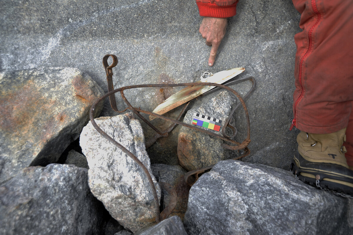
Using a pulse induction metal detector and a coil to place down the ice auger holes, we found that the only place with a positive reading was the spot where we previously determined the frame sank. The ice auger also brought up a small piece of corroded wire from this area.
Putting it all together
This search has taken months of preparation, help from many interested parties, including the Australian Antarctic Division, and a physical search on three consecutive expeditions. We are now in a position to make some comments, all of which point to the likely location of the frame:- The harbour bottom is a shallow flat structure, which continues under the ice where the plane sank.
- The ice in the search area is three metres deep and shows evidence of a substantial melt in the past.
- There is only one place where we found metal, and ground penetrating radar shows an anomaly in this area.
It is likely that something lies three metres under the ice. It might be the frame, or it might be fragments. Ice auger drilling and metal detection are effective and fast ways to search the area. A dig should be attempted, but it takes about two days and four people to make a big enough hole. One hole is about the limit for one expedition, so it needs a bit more confirmation before the chainsaws come out.
On New Year’s Day 2010 the tide was extraordinarily low, and one of our carpenters was poking around the sea edge near the search area. He found four connecting pieces, about 100mm in size each, from the last section of the tail, which was cut off before the frame was abandoned. The media turned this into the frame being ‘found', which of course it wasn’t.
What it does show though is that the frame, or parts of it, can survive for nearly 100 years in this environment. This gives us further hope that when the next expedition digs for the frame, there will be something to find.
DR CHRIS HENDERSON
Mawson’s Huts Foundation
Was the Air Tractor a Vickers No.1 or Vickers No.2?
There has been some discussion about the designation of the air tractor — whether it was the first or second Vickers plane. In fact it was originally No. 2, but was promoted to No. 1 (Harald Penrose, British aviation — the pioneer years, p. 308):
' … A.R. Low [the designer of the Vickers-R.E.P No.1 Monoplane] was phoned by Bertie Wood, who asked him to go to Brooklands to watch test flights being conducted by Robert Fenwick and Lieut. H.E. Watkins acting on behalf of Dr. Douglas Mawson, to whom Captain Wood had sold the next Vickers-R.E.P. for the following year’s Australian Antarctic Expedition. Fenwick took off with an abnormally sharp climb, turned sharply at the end of the aerodrome, stalled, and spun half a turn in the ground. Vickers had quickly acquired their first repair job … '
Herbert Wood did not let it be generally known that the first machine had crashed. No. 2 was quickly substituted and redesignated No. 1 and then sent to Australia for Mawson. In short, Mawson ordered the No. 2, but owing to the crash of the first aircraft Mawson’s aircraft was promoted.