
A mysterious mountain range hidden in the heart of Antarctica is the focus of a major field project, ‘Antarctica’s Gamburtsev Province’ or ‘AGAP', involving the Australian Antarctic Division in the 2008–09 season.
The Gamburtsev subglacial mountain range is 1200km long and 3400m high. The mountains are unusual in that they are buried under 600m of ice and situated in the interior of the continent. They were discovered by a Soviet team during the International Geophysical Year (1957–58), on a traverse to the Pole of Inaccessibility — the point inland furthest from any coast.
The topographic nature and location of the foothills to these subglacial mountains were identified during Australia’s 2002–03 Prince Charles Mountains Expedition of Germany and Australia (PCMEGA). This involved an airborne geophysical survey over the southern extension of the Lambert Glacier (Australian Antarctic Magazine 5: 2–6, 2003).
Scientists believe the mountains hold clues to the origin and evolution of Antarctica and, by extension, the Earth’s current climate. Computer modelling suggests the mountain peaks were a nucleation point for the ice sheets that now cover the continent. However, given the difficulty in accessing the area, the mountains have been little studied.
That’s all about to change as United States scientists (responsible for the overall planning coordination of AGAP) team up with scientists from Australia, the United Kingdom, Germany, China, France, Italy and Japan, to undertake airborne geophysics and seismic surveys of the subglacial Gamburtsev Mountains that will build on the results from the PCMEGA survey.
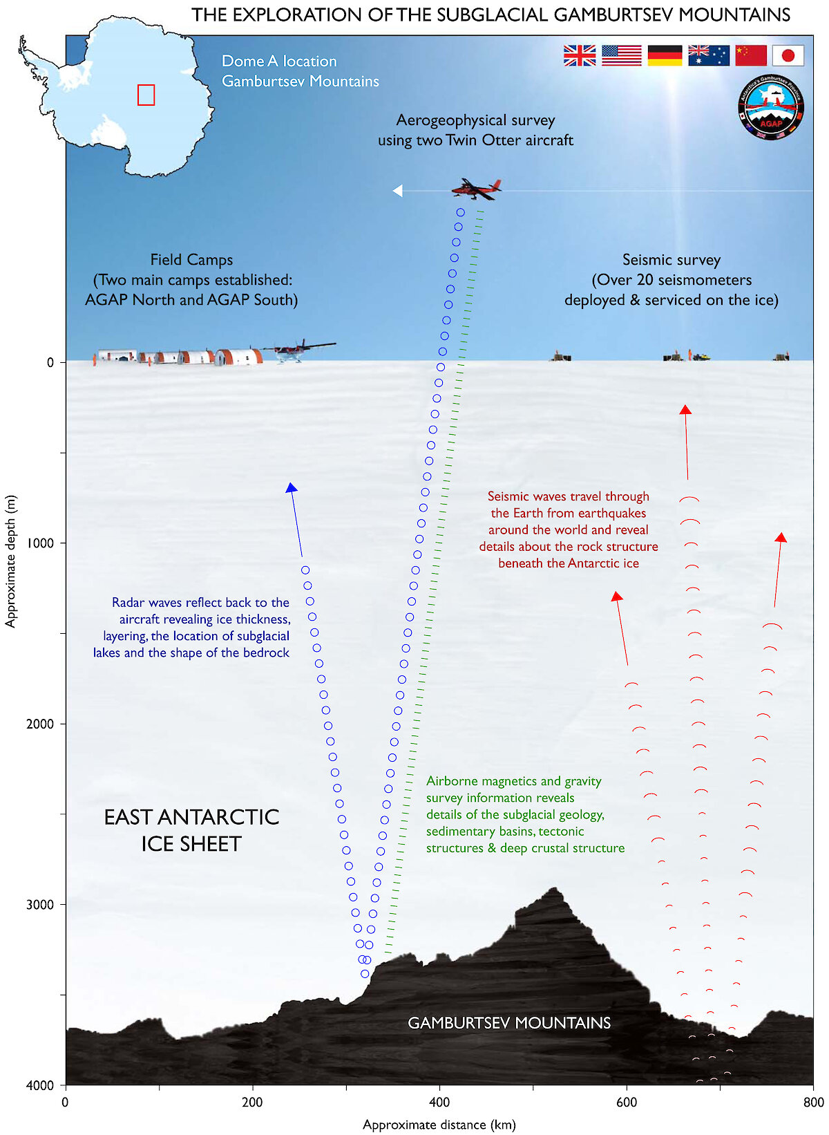
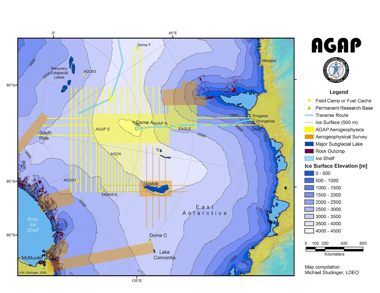
To discover the evolutionary history of the mountains – what they are, where they come from, and how old they are – the scientists will establish two field camps (AGAP-North and AGAP-South) from which to conduct the work. A major component of the project will be an aerial geophysical survey to study the mountains' topography and take gravity and magnetic readings (see graphic). This will help explain how the mountains were formed.Seismic stations around the province will also provide information on the structure of the mantle and crust beneath the mountains, giving insights into why the mountains are so high and how old they are.
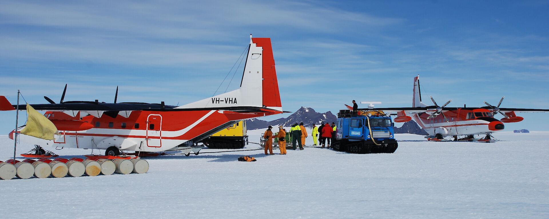
The Australian Antarctic Division is contributing a range of resources to the project, including personnel, food, vehicles, medical and communications equipment at the AGAP-North camp, and a C212 aircraft and helicopters to assist with the logistics of the project.
The AGAP project will further our understanding of the origin and the influences of the subglacial Gamburtsev Mountains. The main aim is to derive a four dimensional evolutionary history of the area of East Antarctica affected by the Lambert glacier and the associated Amery Ice Shelf.The project will survey a transect from the centre of the Antarctic continent, where the ice sheet is underlain by the Gamburtsev Mountains, northwards into Prydz Bay. To create a 3-D map of what lies beneath the ice sheet, two aircraft will complete the first aerogeophysical survey over the Gamburtsev Mountains and Dome A. Results from this aircraft mission, combined with data from a suite of seismic instruments on the ice, will unlock the secrets hidden beneath the ice
Airborne radar measurements will also contribute to scientists’ understanding of ice thickness, layering, the location of any subglacial lakes, and the shape of the bedrock in the survey region. More than 200 subglacial lakes have been located in Antarctica using airborne radar and satellite measurements. Water moves between these lakes through a complex system of under-ice rivers, streams and even swamps. Scientists believe water under the ice sheet lubricates the underside of the ice, making the ice sheet slide faster.
AGAP — making it happen
The Antarctica’s Gamburtsev Province (AGAP) expedition is a logistically intensive exercise requiring detailed planning and coordination. The expedition will see Twin Otter (UK), Basler (Germany) and C212 (Australia) light aircraft operate out of Davis, supported by a camp staffed by Australian Antarctic Division and British Antarctic Survey expeditioners.
The camp will be at 3000m in altitude and 530nm from Davis. Four hundred and fifty fuel drums will be dropped into the camp by parachute from a US C-17 aircraft (flying from Christchurch), for some 25 days of survey flying by a Twin Otter. Australia’s C-212 will resupply and then recover the people and camp. Expeditioners will then return to Hobart by ship and A319 aircraft. A Chinese traverse returning from the summit of Dome A will retrieve the waste and heavy cargo from the camp site at the end of the season. Watch out for a full report on the expedition in a future issue of the Australian Antarctic Magazine.
Wendy Pyper