


Navy surveyors using the latest multi-beam echo sounding technology over the seabed at Casey have identified underwater features that reveal the past extent of the Antarctic continental ice sheet.
For some 30 years the Royal Australian Navy’s Hydrographic Survey Branch, with the support of the Australian Antarctic Division, has conducted numerous seabed surveys in Antarctica and the subantarctic. These surveys have primarily mapped the approaches to Australia’s four permanent research stations.
With the exception of a collaborative activity involving Geoscience Australia at Davis in 2009–10, all of this survey work has been conducted using outdated single beam echo sounders. Although these sonars are useful in collecting depth information and producing nautical charts, they are unable to provide detailed representations of the seabed. This limitation prevents the discovery of all potential hazards to surface navigation and restricts the utility of the data to scientific research
In 2013–14 a group of four hydrographic surveyors and one marine technician from the Navy’s Deployable Geospatial Support Team deployed to Casey on the RSV Aurora Australis. The team was tasked with conducting a hydrographic survey of Newcomb Bay and O’Brien Bay. This marked the first occasion for almost a decade that a naval vessel had been part of the Australian Antarctic program.
Although the Navy’s vessel Wyatt Earp has previously operated in Antarctica and at Macquarie Island, this was its first deployment since a refurbishment and the installation of a new multibeam echo sounder that can provide high resolution depictions of the sea floor. Trialling this new sonar was an important component of the year’s activity and the quality of the data produced, together with its immediate relevance to some of Australia’s Antarctic science projects, was very pleasing. The use of this data to support research activities was a new frontier for Navy surveyors, who primarily collect data for charting and military use. Because of this, the survey at Casey represented a significant cognitive leap forward, which was nicely complemented by the technological leap offered by the new sonar.
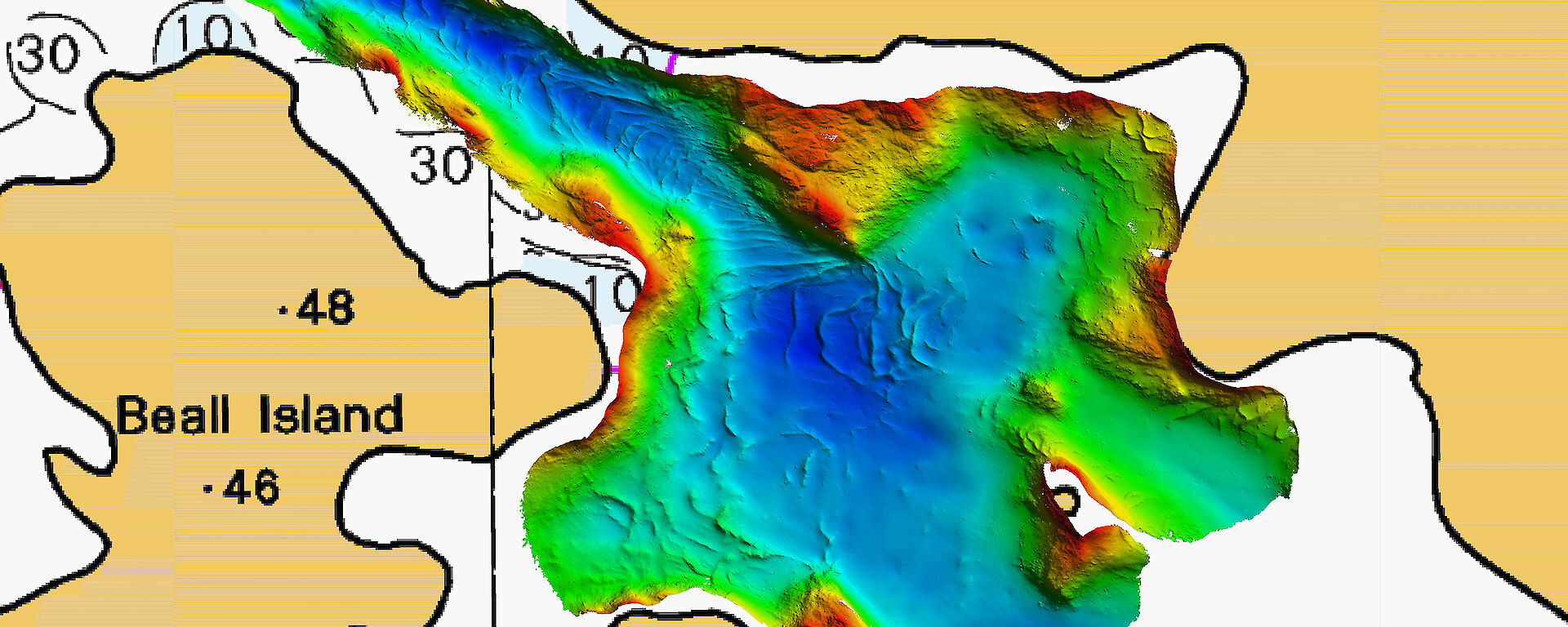
The images generated by the multibeam sonar showed an incredibly dynamic sea floor. Particularly striking features were large crescent shaped ‘moraines’ (piles of glacial detritus), created during pauses in past ice sheet retreat (see 'Seabed structure in detail'). The moraines mark where the ice sheet grounding-zone (the point where the ice-sheet meets the sea floor) remained long enough to melt and drop gravel and rock debris that had previously been frozen in to the base of the ice sheet. Although hundreds of metres long, these features were previously unknown from Casey, being too large for divers to recognise them for what they are.
Australian Antarctic Division science program leader, Dr Martin Riddle, first attempted to map seabed habitats at Casey in 1997, but the acoustic technology available at that time was unsuitable. While at Casey for another science project in 2013, Dr Riddle was on hand to receive daily progress reports. His obvious excitement was very gratifying and spurred the team on to cover as much ground as possible.
According to Dr Riddle the multibeam data is essential for understanding the nature and scales of natural environmental variability, so that scientists can identify the subtle signals of environmental change caused by human activity. Until now, knowledge of coastal seabed ecosystems in the Casey region has been limited to the tiny snapshots of information gained by divers. The new multibeam data will allow scientists to join up the detailed information from the few places scientific teams have dived, and build a picture of the whole coastal area.
Our survey at Casey was interrupted by the requirement to assist a stricken Russian vessel trapped in ice near Commonwealth Bay. The multinational effort to rescue the passengers was a well timed reminder of the remoteness and scale of the Antarctic continent and the challenges faced when responding to an incident at sea. As the number of vessels transiting the Antarctic increases, the importance of improved charting will continue to rise.
The lack of adequate charting poses a significant threat to shipping in an environment where the consequences of any incident will likely be catastrophic. The International Hydrographic Organization has established the Hydrographic Commission on the Antarctic to encourage survey activities in the Antarctic and to coordinate an international charting scheme. However, very large areas remain to be adequately surveyed and the task of improving the safety of Antarctic navigation is daunting.
During the six days of survey operations at Casey the team faced unique challenges; some expected, others not. It is hoped that the lessons learnt from these challenges will provide a firm foundation for the continued growth of the program in the years ahead. It is also hoped that further collaboration with the Antarctic Division and Geoscience Australia will provide a strong basis for detailed planning to ensure outcomes are reached that serve the needs of both science and the safety of navigation. For Navy personnel accustomed to only interacting with other members of the Australian Defence Force, this collaboration was a highlight, as was the opportunity to witness the operations of the Antarctic Division and P&O Shipping in an extremely difficult yet spectacular environment.
Lieutenant Peter Waring
Deployable Geospatial Support Team


