This week we celebrate 60 years of Davis, opening of the boating season and a hut upgrade.
Preparing for the boating season
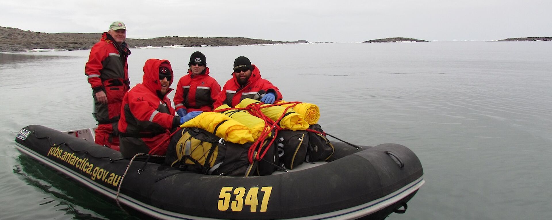
The sea ice has finally gone and the boating season at Davis has officially opened!
Many expeditioners are keen to participate in a berg cruise, but for those of us involved in the Hydrographic Surveying and Seafloor Characterisation Project, it means it is time to get to work. Our project is a collaboration between Geoscience Australia, the Royal Australian Navy and the Australian Antarctic Division (AAD) and our job is to map and characterise the seafloor.
We use a variety of equipment, including multibeam echosounders, sediment grabs, corers, sub-bottom profilers and underwater cameras. The information we collect is vital for safe navigation in Antarctic waters and to support a range of scientific, environmental management and operational activities.
The project team arrived at Davis in mid–December and have been eagerly checking the sea ice conditions every day in the hope that it would quickly disperse so we could begin work. It finally broke out just after New Year’s Day, but before we could actually begin surveying we had a few things to complete.
First, we had to test getting the boats in and out of the water. We have two workboats this season: the Navy’s Antarctic Survey Vessel (ASV) Wyatt Earp, and the AAD’s workboat Howard Burton.
Our first attempt at launching the boats was made a little difficult by a juvenile emperor penguin who decided to stand in the middle of the road as the boats were being towed from the station down to the wharf. Having lost the Mexican standoff with the penguin we decided to take an alternative road and finally made it to the wharf, only to discover that the boat trailers and the ramp were not going to work harmoniously. So, after much to-ing and fro-ing, we are now launching the boats using the crane. A big shout-out to Ed and Dors, the plant operators who have been incredibly patient and supportive.
Before we could start surveying, we also had to make sure that all the boating crew on station were familiar with procedures and the local navigational hazards. The boating crew consisted of the project team plus qualified coxswains, FTOs and competent crew in three inflatable boats.
For safety reasons, it is important that there are at least two boats in the water at all times and that we have multiple redundancies for everything in case something goes wrong.
We carry several radios, satellite phones, EPIRBs, survival kits, stoves and food rations etc. We also have to be very conscious of the wildlife and maintain suitable distances so that we don’t disturb their nesting sites.
There are also a number of shoals in the vicinity so it is important to know where these are so we don’t run aground or capsize (the water temperature is approx. −1°C so we really don’t want to fall in). Another hazard is icebergs, and during our boating familiarisation exercise we were fortunate enough to see an iceberg split in two and roll over with many experienced Antarctic expeditioners unsure if the loud shriek was from the berg or our intrepid boat leader Pete. It was spectacular and a timely reminder of why we need to maintain safe distances from the icebergs as there were no warning signs!
So now we are ready to begin the survey. Keep an eye out for our next update where we will hopefully have some spectacular images of the seafloor environment around Davis station.
Jodie
Davis’ 60th anniversary
Friday the 13th of January will mark the 60th anniversary of the opening of Davis station back in 1957.
This week we look back at the conditions and facilities provided for that initial Davis wintering team.
After journeying from Mawson, the Kista Dan arrived at the Vestfold Hills near Magnetic Island on 11th January 1957. An aerial recce of the coast was undertaken by Phil Law (the then Director of the Antarctic Division) and Grove the pilot.
Law noted three inlets and three indentations that could potentially be suitable as sites for the station. He returned to the ship and at 11 pm (24 rs of sunlight in early January), and took Dingle, Macey, Stinear, Gallasch and Heidemann in the ship’s boat to examine the shoreline more closely.
None of the sites looked promising initially, but on closer examination of an indentation Law had labelled ‘B’, it was decided that, although not ideal because a lack of water supply, this site could work.
At around midday the following day, the first DUKW (amphibious vehicles) landed on the beach, unloaded some cargo and the men cleared a track from the beach to the building site with picks and shovels. They set up a temporary camp on the beach and brought the hut sections ashore. Construction of the station huts started in earnest the following morning — Sunday 13th January.
As Phil Law states: ‘At 1600 hours on January 13th 1957 work stopped and all hands assembled around a flagpole, which had been strapped to the wall of the first hut being erected, which was the sleeping hut. Phillip Law made short speech stressing the importance of the new station in the IGY program. This was followed by short account of achievements of Captain John King Davis, the singing of God Save the Queen, three cheers and then back to work'.
The station basically consisted of three main huts (sleeping, community and powerhouse — all connected), along with a store, a garage and an aurora observatory.
The sleeping hut:
This was the first building erected at Davis and was basically an aluminium sheathed hut with five single cubicles. Each had a raised bunk with desk and drawers underneath. The hut was heated electrically by a heater at one end and the warm air ducted to each compartment at floor level.
The community hut:
Contained the kitchen, mess, radio room and met office and was joined by a corridor to the sleeping hut. The five wintering expeditioners basically spent their time in a “living” area that was little more than 15 ft by 10 ft (14m²).
This hut was barely suitable for its intended role: by mid–May snow drifts had sealed off the main access resulting in access via the corridor to the Engine Hut or via the roof hatches. By September, considerable water leaks were occurring through the walls and roof as the winter snow drifts began to thaw. Apart from the corridors that joined the community hut to the sleeping hut, another corridor was installed to join this hut to the engine hut.
The engine hut:
Initially housed the two Lister 15kVa generator plants, a small workshop and the station bathroom.
Water was obtained in winter by using heat exhaust from the engines to melt ice, and in summer a solar still was used to desalinate seawater. Fresh water was a major concern and the chief engineer of the Kista Dan rigged up a distilling plant with two electric elements.
Bob Dingle (OIC) years later fessed up that alternative methods were also adopted: “We had a small plywood dinghy on the base with us, and if we saw a little bit of ice floating down the bay, we’d jump in the dinghy and go out and lasso this bit of ice and bring it into shore. And then take it back to camp and chop it up and put it into the snow melter. But once we had our first blizzard (and the snow came) we had no problem as far as water was concerned after that.”
W.R.J. Dingle interviewed by Tim Bowden ABC — 25 Nov 1987
The solar still to produce fresh water from salt water was one of many different methods adopted over the next 50 years to supply adequate fresh water at Davis. The black cylindrical container with tap and length of hose was designed to store seawater. Reverse osmosis is now utilised at Davis to carry out the same task.
The store hut:
This hut was isolated from the other buildings to serve as an emergency shelter should the main buildings be damaged as a result of fire.
The garage:
Was also constructed away from the main buildings and apart from the storage of vehicles (Fergie Tractor that winter), but also where met balloons could be filled with hydrogen.
The aurora hut:
Was a perspex-domed observatory located on the slope above the station, housing the all sky camera for aurora photography.
The balloon theodolite shelter was never considered part of the station proper due to its distance from the main buildings, but served its purpose through to 1994 when a new meteorology shelter was commissioned.
By the evening of January 20th (eight days after starting), the station was deemed ready for occupation and the Kista Dan set sail for Mawson. It returned in mid February to drop off Nils Lied who had just completed a winter at Mawson and had volunteered to double up.
The first wintering party comprised of:
W.R.J. Dingle, OIC & Met: Previous winters at Heard Island — 1947, Mawson — 1954 and Macquarie Island — 1956 (Bob Dingle travelled back to Australia from Macquarie Island on the December 1956 relief voyage and six days later was heading south to Davis).
B. Steiner, Geologist: Mawson — 1954
A.C. Hawker, Radio Supervisor: Macquarie Island — 1954
N.T. Lied, Radio Officer: Heard Island — 1951 and Mawson — 1956
W.C. Lucas, Diesel Mechanic: First Winter
Their main scientific tasks were carrying out a geological survey of the east coast of Prydz Bay, and conducting meteorological and auroral observations.
The party was not completely isolated, as Beaver aircraft flew between Mawson station (established February 1954) and Davis several times transferring personnel and supplies.
During May of 1957, the Mawson surveyor Morris Fisher spent time at Davis and later on in August, Bruce Stinear was flown 637 kilometres to Mawson to continue his geology work.
Although the buildings did have their problems some of them were in continuous use into the early 2000s. None of the original station remains at Davis, with the last of the buildings being removed during the 2007–08 summer.
So finally a happy 60th birthday to Davis — of the 79 of us here at present, only four of us have also reached that milestone.
Mark
Trajer Ridge Hut replacement
The ever-welcoming Trajer Ridge Melon has supported field training sessions and offered refuge to parties travelling on the plateau for many years and this season it is expecting a makeover. A bigger and better Melon will be positioned in the existing site and works are well underway.
Phase 1: Decommissioning party, and likely the last people to stay in the 1989-built Melon, were flown to the site to empty all its contents. Jen, Dave, Vas and Seamus took in the sights and moved everything from the Melon into cage pallets ready to be slung back to station by helicopter. Stand by for updates as this project continues…
Jen
Modernisation and year-round aviation access
Geotechnical investigations into year round aviation access at Davis station has not been without challenges. Delays, inductions, broken drill rigs, windy weather, field training, flooding, limited staffing and errant penguins have all made their mark. However, there have also been some great achievements.
Drilling in Heidemann Valley is exploring deeper than any previous drilling program, revealing a sub-surface history not seen before. Combine drilling with geophysics, geology and all the supporting works, and we are starting to see a picture developing for Heidemann Valley, one that is not without its surprises.
But let’s not get ahead of ourselves. The work being completed in Heidemann Valley and the Ridge area as part of Project 5097 is certainly exciting and challenging, but the project is only the latest in a series of investigations exploring the prospect of fixed-wing aviation access direct to Davis. As it stands, science at Davis is supported by ice runways and a ski way located on the ice sheet some 40 kilometres east of the station.
The ice is open to lighter aircraft and for only a limited time, from the end of winter until the ice loses strength into spring. The ski way, locally known as Whoop Whoop, is typically colder and the katabatic winds blow harder than at Davis.
Use is limited to summer only and traffic from Whoop Whoop to Davis is bottle-necked by helicopters or uncomfortable four hour trips across ice in Hägglunds. Neither are without hazard.
The idea of a gravel runway in the Vestfold Hills is not new. The first serious investigations commenced back in the early 1980s. There was no drilling, but sites were accessed and pits were dug using dozers and excavators. Dingle Road is a product of these investigations and is today a key piece of station infrastructure and access for those seeking a walk or separation from the closeness of station life.
Blazing trails was not without cost and early investigators soon found that the solid crust often afforded foot traffic was not so accommodating of heavier equipment. Ideas of an easy runway faded almost as fast as the trucks sank beyond their axles. Clearly, a more thorough sub-surface investigation was required and, as time passed, one that was more sensitive to the environment in which the investigation was being undertaken.
After several decades of discussion and review, a program of drilling was planned for 2012. However, fate struck again with the early loss of fast ice at Davis a barrier to landing a drill rig in Antarctica. Further evidence perhaps in support of more reliable access to Davis.
To 2016, and Project 5097 comprises a team of engineers, geologists, geophysicists, surveyors, plant operators, drillers and their gear. The team is tasked with collecting a level of geotechnical information necessary to assess the viability of constructing an all-year runway at Davis.
Construction of a runway is not the only option for year round access under the government’s 20-year plan, but it is one being afforded serious consideration given a long history of debate by generations of explorers and scientists. It is the best resourced and most thorough investigation undertaken to assess the viability of a runway at Davis to date.
The focus of work is near to Davis station in the Heidemann Valley. This valley is near-to flat and the valley itself oriented close in to the prevailing northeasterly wind. It is serviced by the existing Dingle Road, and it hosts existing radar and weather monitoring infrastructure. While it has been the site for smaller-scale investigations in the past, Project 5097 is the first to consider the characteristics and assess the potential impacts of constructing a runway on the valley (as a whole) as well as its surrounds.
Work is ongoing, but to date drilling has penetrated deeper into the glacial sediment filling Heidemann Valley than has been achieved by any previous investigation. By project end, we aim to complete a series of holes underpinning broader interpretations of the valley sub-surface made using geophysics.
This work is already yielding results. Indications are that Heidemann valley is not one valley but two and the upper half separated from the lower by a buried ridge of ancient rock. The sediment fill is also deeper than anticipated. Earlier studies concluded a depth to the rocky valley bottom of less than five metres. Yet, drilling in the same locations shows sediment extending to depths exceeding 20 metres with no sign of hard rock.
On completion of the 2016/17 season, drilling and geophysical data will be combined with mapping of the glacial sediments to produce a three-dimensional model of the valley. Installation of temperature and water sensors in monitoring bores in the drill holes will continue to inform as to how the valley changes across seasons, and how ice forms and melts in the ground.
This information will be provided to engineers who can then estimate how a runway might be built and to scientists who can assess how a runway might impact on the wider environment. And, while Project 5097 might be the most comprehensive geotechnical program undertaken for year-round aviation access to date, we aim that its legacy on the ground might also be noticed by future generations.